Cocoyoc geodata
Cocoyoc (Morelos) is a populated place; located in Mexico in America/Mexico_City (GMT-6) time zone. With population of 9,663 people, there are 990 cities with bigger population in this country. Compared to other cities in Mexico, 67.4% of cities are located further ↑North; 50.5% of cities are located further ←West and 52.2% of cities have higher elevation than Cocoyoc. Note1


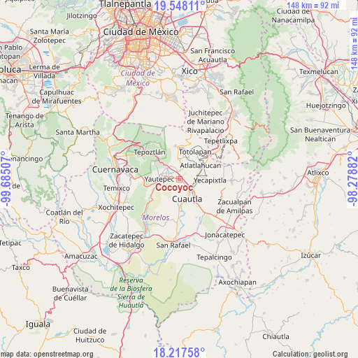
Cocoyoc GPS coordinates[2]
18° 53' 3.012" North, 98° 58' 54.984" West
| Map corner | latitude | longitude |
|---|---|---|
| Upper-left | 19.54811°, | -99.68507° |
| Center: | 18.88417°, | -98.98194° |
| Lower-right: | 18.21758°, | -98.27882° |
| Map W x H: | 147.9×147.9 km | = 91.9×91.9mi |
| max Lat: | 32.7° ⇑67.4% North |
| Cocoyoc: | 18.88417° |
| min Lat: | ⇓32.6% South 14.53588° |
| min Long | Cocoyoc | max Long |
| -117.105° | -98.98194° | -86.73105° |
| W 50.5%⇐ | ⇒49.5% E |
Elevation
Elevation of Cocoyoc is 1327 m = 4354 ft, and this is 73.3 m = 240 ft above average elevation for this country.
| Max E: |
3497 m = 11473 ft | 52.2% |
| Cocoyoc | 1327 m 4354 ft | |
| Avg. | 1253.7 m = 4113 ft | |
Min E: |
-1 m = -3 ft | 47.8% |
See also: Mexico elevation on elevation.city.
Geographical zone
Cocoyoc is located in North Torrid zone (between Equator and Tropic of Cancer). Distance of this Northern Tropic circle is 506.2 km =314.5 mi to North.| Distance of | km | miles | from Cocoyoc |
|---|---|---|---|
| North Pole | 7907.3 | 4913.4 | to North |
| Arctic Circle | 5301.5 | 3294.2 | to North |
| Tropic Cancer | 506.2 | 314.5 | to North |
| Equator | 2099.7 | 1304.7 | to South |


Nearby cities:
15 places around Cocoyoc: (largest is in red/bold)
• 19 de Febrero de 1812
2 km =1.2 mi,  109°
109°
• Calderón
2.9 km =1.8 mi,  173°
173°
• Colonia Puente Pantitlán
4.2 km =2.6 mi,  348°
348°
• Corral Grande
5.1 km =3.2 mi,  13°
13°
• Emiliano Zapata (Casahuates)
5.7 km =3.5 mi,  25°
25°
• Ex-Hacienda el Hospital
6.1 km =3.8 mi,  194°
194°
• Itzamatitlán
5.1 km =3.2 mi,  303°
303°
• Las Minas
5.3 km =3.3 mi,  80°
80°
• Los Arcos
4.5 km =2.8 mi,  274°
274°
• Narciso Mendoza
1.7 km =1.1 mi,  130°
130°
• Oacalco
6.6 km =4.1 mi,  311°
311°
• Oaxtepec
4.6 km =2.9 mi,  35°
35°
• Peña Flores (Palo Verde)
2.4 km =1.5 mi,  142°
142°
• Rancho Cuachixolotera
3.1 km =1.9 mi, 75°
• Tierra Larga (Campo Nuevo)
4.2 km =2.6 mi,  121°
121°
Sources, notices
• [Note1] Compared only with cities in Mexico existing in our database
• [Src1] Map data: © OpenStreetMap contributors (CC-BY-SA)
• [Src2] Other city data from geonames.org with taken over terms of usage.
• [Src3] Geographical zone / Annual Mean Temperature by Robert A. Rohde @ Wikipedia
