Coba geodata
Coba (Quintana Roo) is a populated place; located in Mexico in America/Cancun (GMT-5) time zone. With population of 1,167 people, there are 7434 cities with bigger population in this country. Compared to other cities in Mexico, 67.4% of cities are located further ↓South; 99.8% of cities are located further ←West and 90.4% of cities have higher elevation than Coba. Note1


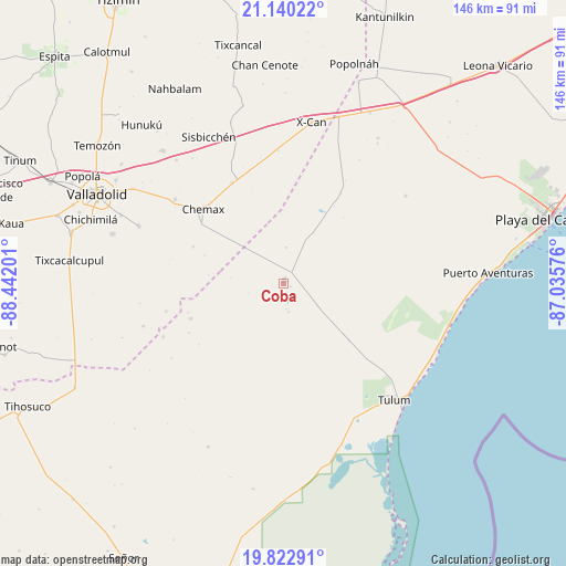
Coba GPS coordinates[2]
20° 28' 58.728" North, 87° 44' 19.968" West
| Map corner | latitude | longitude |
|---|---|---|
| Upper-left | 21.14022°, | -88.44201° |
| Center: | 20.48298°, | -87.73888° |
| Lower-right: | 19.82291°, | -87.03576° |
| Map W x H: | 146.5×146.5 km | = 91×91mi |
| max Lat: | 32.7° ⇑32.6% North |
| Coba: | 20.48298° |
| min Lat: | ⇓67.4% South 14.53588° |
| min Long | Coba | max Long |
| -117.105° | -87.73888° | -86.73105° |
| W 99.8%⇐ | ⇒0.2% E |
Elevation
Elevation of Coba is 23 m = 75 ft, and this is 1230.7 m = 4038 ft below average elevation for this country.
| Max E: |
3497 m = 11473 ft | 90.4% |
| Avg. | 1253.7 m = 4113 ft | |
| Coba | 23 m = 75 ft | |
Min E: |
-1 m = -3 ft | 9.6% |
See also: Mexico elevation on elevation.city.
Geographical zone
Coba is located in North Torrid zone (between Equator and Tropic of Cancer). Distance of this Northern Tropic circle is 328.4 km =204.1 mi to North.| Distance of | km | miles | from Coba |
|---|---|---|---|
| North Pole | 7729.6 | 4802.9 | to North |
| Arctic Circle | 5123.7 | 3183.7 | to North |
| Tropic Cancer | 328.4 | 204.1 | to North |
| Equator | 2277.5 | 1415.2 | to South |


Nearby cities:
15 places around Coba: (largest is in red/bold)
• Chanchen Primero
25.5 km =15.8 mi,  248°
248°
• Chechmil
39.9 km =24.8 mi,  323°
323°
• Chemax
28.2 km =17.5 mi,  313°
313°
• Chulutan
25.1 km =15.6 mi,  292°
292°
• Ciudad Chemuyil
42.9 km =26.7 mi,  110°
110°
• Cocoyol
34.3 km =21.3 mi,  358°
358°
• Dzitox
37.9 km =23.5 mi, 252°
• Francisco Uh May
20.3 km =12.6 mi,  130°
130°
• Kanxoc
40.2 km =25 mi, 291°
• Kuxeb
43.9 km =27.3 mi,  341°
341°
• Macario Gómez
22.4 km =13.9 mi, 130°
• San Silverio
33.9 km =21.1 mi, 246°
• Tulum
41.7 km =25.9 mi,  136°
136°
• Uspibil
42.1 km =26.2 mi, 319°
• X-Cán
42.2 km =26.2 mi,  9°
9°
Sources, notices
• [Note1] Compared only with cities in Mexico existing in our database
• [Src1] Map data: © OpenStreetMap contributors (CC-BY-SA)
• [Src2] Other city data from geonames.org with taken over terms of usage.
• [Src3] Geographical zone / Annual Mean Temperature by Robert A. Rohde @ Wikipedia
