Tulum geodata
Tulum (Quintana Roo) is a seat of a second-order administrative division; located in Mexico in America/Cancun (GMT-5) time zone. With population of 18,233 people, there are 536 cities with bigger population in this country. Compared to other cities in Mexico, 61.6% of cities are located further ↓South; 99.9% of cities are located further ←West and 99.3% of cities have higher elevation than Tulum. Note1


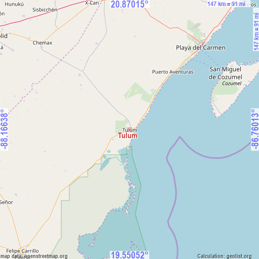
Tulum GPS coordinates[2]
20° 12' 42.228" North, 87° 27' 47.7" West
| Map corner | latitude | longitude |
|---|---|---|
| Upper-left | 20.87015°, | -88.16638° |
| Center: | 20.21173°, | -87.46325° |
| Lower-right: | 19.55052°, | -86.76013° |
| Map W x H: | 146.7×146.7 km | = 91.2×91.2mi |
| max Lat: | 32.7° ⇑38.4% North |
| Tulum: | 20.21173° |
| min Lat: | ⇓61.6% South 14.53588° |
| min Long | Tulum | max Long |
| -117.105° | -87.46325° | -86.73105° |
| W 99.9%⇐ | ⇒0.099999999999994% E |
Elevation
Elevation of Tulum is 5 m = 16 ft, and this is 1248.7 m = 4097 ft below average elevation for this country.
| Max E: |
3497 m = 11473 ft | 99.3% |
| Avg. | 1253.7 m = 4113 ft | |
| Tulum | 5 m = 16 ft | |
Min E: |
-1 m = -3 ft | 0.7% |
See also: Mexico elevation on elevation.city.
Geographical zone
Tulum is located in North Torrid zone (between Equator and Tropic of Cancer). Distance of this Northern Tropic circle is 358.6 km =222.8 mi to North.| Distance of | km | miles | from Tulum |
|---|---|---|---|
| North Pole | 7759.7 | 4821.7 | to North |
| Arctic Circle | 5153.8 | 3202.4 | to North |
| Tropic Cancer | 358.6 | 222.8 | to North |
| Equator | 2247.3 | 1396.4 | to South |


Nearby cities:
15 places around Tulum: (largest is in red/bold)
• Akumal
25.8 km =16 mi,  37°
37°
• Barceló Maya
38.1 km =23.7 mi, 36°
• Chanchen Primero
56.6 km =35.2 mi,  291°
291°
• Chulutan
65.4 km =40.6 mi,  307°
307°
• Chumpón
43.2 km =26.8 mi,  237°
237°
• Chun-Yah
49.8 km =30.9 mi,  255°
255°
• Ciudad Chemuyil
19.1 km =11.9 mi, 37°
• Coba
41.7 km =25.9 mi,  316°
316°
• Cozumel
63 km =39.1 mi,  59°
59°
• Francisco Uh May
21.6 km =13.4 mi, 322°
• Las Fincas
65.3 km =40.6 mi, 60°
• Macario Gómez
19.4 km =12.1 mi, 322°
• Playa del Carmen
61.1 km =38 mi, 40°
• Puerto Aventuras
40.5 km =25.2 mi, 37°
• San Silverio
62 km =38.5 mi, 285°
Sources, notices
• [Note1] Compared only with cities in Mexico existing in our database
• [Src1] Map data: © OpenStreetMap contributors (CC-BY-SA)
• [Src2] Other city data from geonames.org with taken over terms of usage.
• [Src3] Geographical zone / Annual Mean Temperature by Robert A. Rohde @ Wikipedia
