Chanchen Primero geodata
Chanchen Primero (Quintana Roo) is a populated place; located in Mexico in America/Cancun (GMT-5) time zone. With population of 875 people, there are 9983 cities with bigger population in this country. Compared to other cities in Mexico, 65.7% of cities are located further ↓South; 99.7% of cities are located further ←West and 93.5% of cities have higher elevation than Chanchen Primero. Note1


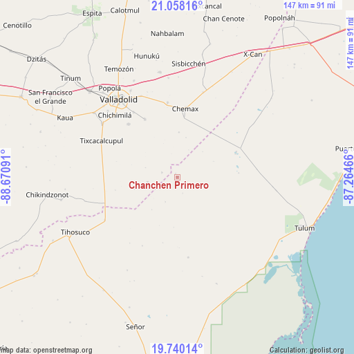
Chanchen Primero GPS coordinates[2]
20° 24' 2.016" North, 87° 58' 4.008" West
| Map corner | latitude | longitude |
|---|---|---|
| Upper-left | 21.05816°, | -88.67091° |
| Center: | 20.40056°, | -87.96778° |
| Lower-right: | 19.74014°, | -87.26466° |
| Map W x H: | 146.6×146.6 km | = 91.1×91.1mi |
| max Lat: | 32.7° ⇑34.3% North |
| Chanchen Primero: | 20.40056° |
| min Lat: | ⇓65.7% South 14.53588° |
| min Long | Chanchen Primer | max Long |
| -117.105° | -87.96778° | -86.73105° |
| W 99.7%⇐ | ⇒0.3% E |
Elevation
Elevation of Chanchen Primero is 16 m = 52 ft, and this is 1237.7 m = 4061 ft below average elevation for this country.
| Max E: |
3497 m = 11473 ft | 93.5% |
| Avg. | 1253.7 m = 4113 ft | |
| Chanchen Primero | 16 m = 52 ft | |
Min E: |
-1 m = -3 ft | 6.5% |
See also: Mexico elevation on elevation.city.
Geographical zone
Chanchen Primero is located in North Torrid zone (between Equator and Tropic of Cancer). Distance of this Northern Tropic circle is 337.6 km =209.8 mi to North.| Distance of | km | miles | from Chanchen Primero |
|---|---|---|---|
| North Pole | 7738.7 | 4808.6 | to North |
| Arctic Circle | 5132.8 | 3189.4 | to North |
| Tropic Cancer | 337.6 | 209.8 | to North |
| Equator | 2268.3 | 1409.5 | to South |


Nearby cities:
15 places around Chanchen Primero: (largest is in red/bold)
• Chan X-Cail
18.7 km =11.6 mi,  254°
254°
• Chemax
28.6 km =17.8 mi,  6°
6°
• Chichimila
36.5 km =22.7 mi,  314°
314°
• Chulutan
18.6 km =11.6 mi,  1°
1°
• Chun-Yah
33.5 km =20.8 mi,  172°
172°
• Coba
25.5 km =15.8 mi,  68°
68°
• Dzitox
12.6 km =7.8 mi,  261°
261°
• Kanxoc
27.5 km =17.1 mi,  330°
330°
• San Silverio
8.5 km =5.3 mi,  237°
237°
• Tekom
38.3 km =23.8 mi, 306°
• Tepich
34.9 km =21.7 mi, 239°
• Tikuch
36.9 km =22.9 mi,  335°
335°
• Tixcacalcupul
34.9 km =21.7 mi,  295°
295°
• Tixhualactún
32.7 km =20.3 mi, 326°
• Xocen
30 km =18.6 mi,  316°
316°
Sources, notices
• [Note1] Compared only with cities in Mexico existing in our database
• [Src1] Map data: © OpenStreetMap contributors (CC-BY-SA)
• [Src2] Other city data from geonames.org with taken over terms of usage.
• [Src3] Geographical zone / Annual Mean Temperature by Robert A. Rohde @ Wikipedia
