Cintalapa geodata
Cintalapa (Chiapas) is a populated place; located in Mexico in America/Mexico_City (GMT-6) time zone. With population of 1,571 people, there are 5496 cities with bigger population in this country. Compared to other cities in Mexico, 90% of cities are located further ↑North; 96.5% of cities are located further ←West and 68.6% of cities have higher elevation than Cintalapa. Note1


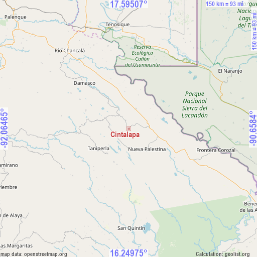
Cintalapa GPS coordinates[2]
16° 55' 24.996" North, 91° 21' 41.472" West
| Map corner | latitude | longitude |
|---|---|---|
| Upper-left | 17.59507°, | -92.06465° |
| Center: | 16.92361°, | -91.36152° |
| Lower-right: | 16.24975°, | -90.6584° |
| Map W x H: | 149.6×149.6 km | = 93×93mi |
| max Lat: | 32.7° ⇑90% North |
| Cintalapa: | 16.92361° |
| min Lat: | ⇓10% South 14.53588° |
| min Long | Cintalapa | max Long |
| -117.105° | -91.36152° | -86.73105° |
| W 96.5%⇐ | ⇒3.5% E |
Elevation
Elevation of Cintalapa is 491 m = 1611 ft, and this is 762.7 m = 2502 ft below average elevation for this country.
| Max E: |
3497 m = 11473 ft | 68.6% |
| Avg. | 1253.7 m = 4113 ft | |
| Cintalapa | 491 m = 1611 ft | |
Min E: |
-1 m = -3 ft | 31.4% |
See also: Mexico elevation on elevation.city.
Geographical zone
Cintalapa is located in North Torrid zone (between Equator and Tropic of Cancer). Distance of this Northern Tropic circle is 724.2 km =450 mi to North.| Distance of | km | miles | from Cintalapa |
|---|---|---|---|
| North Pole | 8125.3 | 5048.8 | to North |
| Arctic Circle | 5519.4 | 3429.6 | to North |
| Tropic Cancer | 724.2 | 450 | to North |
| Equator | 1881.7 | 1169.2 | to South |


Nearby cities:
15 places around Cintalapa: (largest is in red/bold)
• Arroyo Granizo
14.3 km =8.9 mi,  331°
331°
• Busiljá
15.2 km =9.4 mi,  359°
359°
• El Jardín
18.8 km =11.7 mi,  285°
285°
• El Limonar
5.5 km =3.4 mi,  341°
341°
• El Sibal
15.1 km =9.4 mi, 294°
• Nueva Libertad
20.5 km =12.7 mi,  16°
16°
• Nueva Palestina
16 km =9.9 mi,  137°
137°
• Nuevo Francisco León
12.6 km =7.8 mi, 19°
• Nuevo Mariscal
19.8 km =12.3 mi,  71°
71°
• Ojo de Agua
20.1 km =12.5 mi,  319°
319°
• Perla de Acapulco
18.9 km =11.7 mi,  221°
221°
• Plan de Ayutla
13.6 km =8.5 mi,  155°
155°
• Santa Rita
10.5 km =6.5 mi,  267°
267°
• Santo Domingo
13 km =8.1 mi, 333°
• Taniperla
20.6 km =12.8 mi,  236°
236°
Sources, notices
• [Note1] Compared only with cities in Mexico existing in our database
• [Src1] Map data: © OpenStreetMap contributors (CC-BY-SA)
• [Src2] Other city data from geonames.org with taken over terms of usage.
• [Src3] Geographical zone / Annual Mean Temperature by Robert A. Rohde @ Wikipedia
