Ojo de Agua geodata
Ojo de Agua (Chiapas) is a populated place; located in Mexico in America/Mexico_City (GMT-6) time zone. With population of 703 people, there are 12379 cities with bigger population in this country. Compared to other cities in Mexico, 88.1% of cities are located further ↑North; 96.4% of cities are located further ←West and 68.4% of cities have higher elevation than Ojo de Agua. Note1


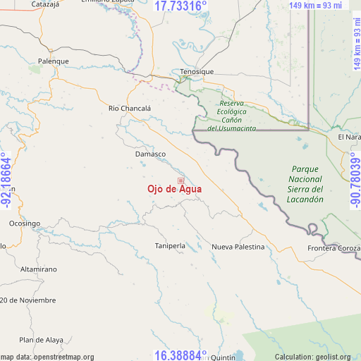
Ojo de Agua GPS coordinates[2]
17° 3' 43.956" North, 91° 29' 0.636" West
| Map corner | latitude | longitude |
|---|---|---|
| Upper-left | 17.73316°, | -92.18664° |
| Center: | 17.06221°, | -91.48351° |
| Lower-right: | 16.38884°, | -90.78039° |
| Map W x H: | 149.5×149.5 km | = 92.9×92.9mi |
| max Lat: | 32.7° ⇑88.1% North |
| Ojo de Agua: | 17.06221° |
| min Lat: | ⇓11.9% South 14.53588° |
| min Long | Ojo de Agua | max Long |
| -117.105° | -91.48351° | -86.73105° |
| W 96.4%⇐ | ⇒3.6% E |
Elevation
Elevation of Ojo de Agua is 501 m = 1644 ft, and this is 752.7 m = 2469 ft below average elevation for this country.
| Max E: |
3497 m = 11473 ft | 68.4% |
| Avg. | 1253.7 m = 4113 ft | |
| Ojo de Agua | 501 m = 1644 ft | |
Min E: |
-1 m = -3 ft | 31.6% |
See also: Mexico elevation on elevation.city.
Geographical zone
Ojo de Agua is located in North Torrid zone (between Equator and Tropic of Cancer). Distance of this Northern Tropic circle is 708.8 km =440.4 mi to North.| Distance of | km | miles | from Ojo de Agua |
|---|---|---|---|
| North Pole | 8109.9 | 5039.3 | to North |
| Arctic Circle | 5504 | 3420 | to North |
| Tropic Cancer | 708.8 | 440.4 | to North |
| Equator | 1897.1 | 1178.8 | to South |


Nearby cities:
15 places around Ojo de Agua: (largest is in red/bold)
• Arroyo Granizo
6.8 km =4.2 mi,  114°
114°
• Busiljá
13 km =8.1 mi,  91°
91°
• Damasco
16.6 km =10.3 mi,  311°
311°
• El Jardín
11.4 km =7.1 mi,  206°
206°
• El Limonar
15.2 km =9.4 mi,  132°
132°
• El Sibal
9.2 km =5.7 mi,  185°
185°
• El Tumbo
15.2 km =9.4 mi,  276°
276°
• Francisco Guerrero
7.5 km =4.7 mi,  357°
357°
• La Arena
7.1 km =4.4 mi,  324°
324°
• Lacandón
12.7 km =7.9 mi,  249°
249°
• Nuevo Francisco León
17.5 km =10.9 mi,  101°
101°
• Nuevo Jericó
10 km =6.2 mi, 320°
• Santa Rita
16.1 km =10 mi,  170°
170°
• Santo Domingo
8 km =5 mi,  118°
118°
• Ubilio García
2.7 km =1.7 mi,  25°
25°
Sources, notices
• [Note1] Compared only with cities in Mexico existing in our database
• [Src1] Map data: © OpenStreetMap contributors (CC-BY-SA)
• [Src2] Other city data from geonames.org with taken over terms of usage.
• [Src3] Geographical zone / Annual Mean Temperature by Robert A. Rohde @ Wikipedia
