El Sibal geodata
El Sibal (Chiapas) is a populated place; located in Mexico in America/Mexico_City (GMT-6) time zone. With population of 1,472 people, there are 5873 cities with bigger population in this country. Compared to other cities in Mexico, 89.2% of cities are located further ↑North; 96.3% of cities are located further ←West and 65% of cities have higher elevation than El Sibal. Note1


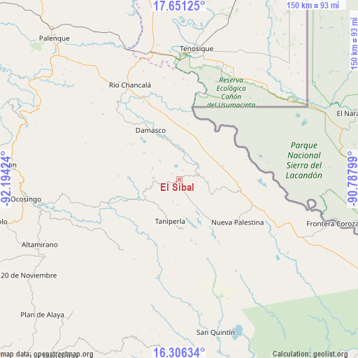
El Sibal GPS coordinates[2]
16° 58' 48" North, 91° 29' 27.996" West
| Map corner | latitude | longitude |
|---|---|---|
| Upper-left | 17.65125°, | -92.19424° |
| Center: | 16.98°, | -91.49111° |
| Lower-right: | 16.30634°, | -90.78799° |
| Map W x H: | 149.5×149.5 km | = 92.9×92.9mi |
| max Lat: | 32.7° ⇑89.2% North |
| El Sibal: | 16.98° |
| min Lat: | ⇓10.8% South 14.53588° |
| min Long | El Sibal | max Long |
| -117.105° | -91.49111° | -86.73105° |
| W 96.3%⇐ | ⇒3.7% E |
Elevation
Elevation of El Sibal is 685 m = 2247 ft, and this is 568.7 m = 1866 ft below average elevation for this country.
| Max E: |
3497 m = 11473 ft | 65% |
| Avg. | 1253.7 m = 4113 ft | |
| El Sibal | 685 m = 2247 ft | |
Min E: |
-1 m = -3 ft | 35% |
See also: Mexico elevation on elevation.city.
Geographical zone
El Sibal is located in North Torrid zone (between Equator and Tropic of Cancer). Distance of this Northern Tropic circle is 717.9 km =446.1 mi to North.| Distance of | km | miles | from El Sibal |
|---|---|---|---|
| North Pole | 8119.1 | 5045 | to North |
| Arctic Circle | 5513.2 | 3425.7 | to North |
| Tropic Cancer | 717.9 | 446.1 | to North |
| Equator | 1888 | 1173.1 | to South |


Nearby cities:
15 places around El Sibal: (largest is in red/bold)
• Arroyo Granizo
9.4 km =5.8 mi,  47°
47°
• Busiljá
16.4 km =10.2 mi,  57°
57°
• Cintalapa
15.1 km =9.4 mi,  114°
114°
• El Censo
14.9 km =9.3 mi,  209°
209°
• El Jardín
4.4 km =2.7 mi,  255°
255°
• El Limonar
12.1 km =7.5 mi,  95°
95°
• La Arena
15.3 km =9.5 mi,  347°
347°
• Lacandón
12 km =7.5 mi,  292°
292°
• Ojo de Agua
9.2 km =5.7 mi,  5°
5°
• San Luis (Guadalupe)
15.6 km =9.7 mi,  251°
251°
• Santa Elena
14.3 km =8.9 mi,  227°
227°
• Santa Rita
7.6 km =4.7 mi,  153°
153°
• Santo Domingo
9.5 km =5.9 mi, 55°
• Ubilio García
11.7 km =7.3 mi, 9°
• Zaragoza
16.2 km =10.1 mi,  281°
281°
Sources, notices
• [Note1] Compared only with cities in Mexico existing in our database
• [Src1] Map data: © OpenStreetMap contributors (CC-BY-SA)
• [Src2] Other city data from geonames.org with taken over terms of usage.
• [Src3] Geographical zone / Annual Mean Temperature by Robert A. Rohde @ Wikipedia
