Chiconcuac geodata
Chiconcuac (State of Mexico) is a populated place; located in Mexico in America/Mexico_City (GMT-6) time zone. With population of 21,738 people, there are 472 cities with bigger population in this country. Compared to other cities in Mexico, 52.9% of cities are located further ↑North; 52% of cities are located further ←West and 84.7% of cities have lower elevation than Chiconcuac. Note1


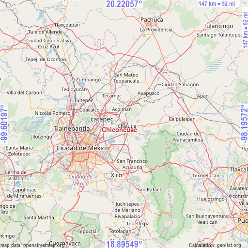
Chiconcuac GPS coordinates[2]
19° 33' 33.804" North, 98° 53' 55.824" West
| Map corner | latitude | longitude |
|---|---|---|
| Upper-left | 20.22057°, | -99.60197° |
| Center: | 19.55939°, | -98.89884° |
| Lower-right: | 18.89549°, | -98.19572° |
| Map W x H: | 147.3×147.3 km | = 91.5×91.5mi |
| max Lat: | 32.7° ⇑52.9% North |
| Chiconcuac: | 19.55939° |
| min Lat: | ⇓47.1% South 14.53588° |
| min Long | Chiconcuac | max Long |
| -117.105° | -98.89884° | -86.73105° |
| W 52%⇐ | ⇒48% E |
Elevation
Elevation of Chiconcuac is 2254 m = 7395 ft, and this is 1000.3 m = 3282 ft above average elevation for this country.
| Max E: |
3497 m = 11473 ft | 15.3% |
| Chiconcuac | 2254 m 7395 ft | |
| Avg. | 1253.7 m = 4113 ft | |
Min E: |
-1 m = -3 ft | 84.7% |
See also: Mexico elevation on elevation.city.
Geographical zone
Chiconcuac is located in North Torrid zone (between Equator and Tropic of Cancer). Distance of this Northern Tropic circle is 431.1 km =267.9 mi to North.| Distance of | km | miles | from Chiconcuac |
|---|---|---|---|
| North Pole | 7832.3 | 4866.8 | to North |
| Arctic Circle | 5226.4 | 3247.5 | to North |
| Tropic Cancer | 431.1 | 267.9 | to North |
| Equator | 2174.8 | 1351.4 | to South |


Nearby cities:
15 places around Chiconcuac: (largest is in red/bold)
• Ampliación Tezoyuca
3.3 km =2.1 mi,  316°
316°
• Atenguillo
2.4 km =1.5 mi,  78°
78°
• Chiautla
2.1 km =1.3 mi,  123°
123°
• Ejido San Cristóbal
1.9 km =1.2 mi,  165°
165°
• La Pastoría
2.2 km =1.4 mi,  215°
215°
• Ocopulco
3.4 km =2.1 mi,  3°
3°
• San Cristóbal Nexquipayac
4 km =2.5 mi,  304°
304°
• San Lucas Huitzilhuacán
3.5 km =2.2 mi,  27°
27°
• San Salvador Atenco
2.2 km =1.4 mi,  247°
247°
• Santiago Chimalpa (Chimalpa)
1.3 km =0.8 mi, 34°
• Tepetitlán
3.3 km =2.1 mi,  63°
63°
• Tezoyuca
3.9 km =2.4 mi,  341°
341°
• Tlaltecahuacán
2.9 km =1.8 mi,  41°
41°
• Tulantongo
4 km =2.5 mi,  140°
140°
• Zapotlán
1.5 km =0.9 mi,  197°
197°
Sources, notices
• [Note1] Compared only with cities in Mexico existing in our database
• [Src1] Map data: © OpenStreetMap contributors (CC-BY-SA)
• [Src2] Other city data from geonames.org with taken over terms of usage.
• [Src3] Geographical zone / Annual Mean Temperature by Robert A. Rohde @ Wikipedia
