Atenguillo geodata
Atenguillo (State of Mexico) is a populated place; located in Mexico in America/Mexico_City (GMT-6) time zone. With population of 1,044 people, there are 8345 cities with bigger population in this country. Compared to other cities in Mexico, 52.8% of cities are located further ↑North; 52.3% of cities are located further ←West and 85.1% of cities have lower elevation than Atenguillo. Note1


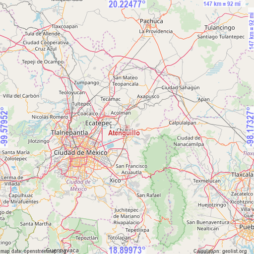
Atenguillo GPS coordinates[2]
19° 33' 48.996" North, 98° 52' 35.004" West
| Map corner | latitude | longitude |
|---|---|---|
| Upper-left | 20.22477°, | -99.57952° |
| Center: | 19.56361°, | -98.87639° |
| Lower-right: | 18.89973°, | -98.17327° |
| Map W x H: | 147.3×147.3 km | = 91.5×91.5mi |
| max Lat: | 32.7° ⇑52.8% North |
| Atenguillo: | 19.56361° |
| min Lat: | ⇓47.2% South 14.53588° |
| min Long | Atenguillo | max Long |
| -117.105° | -98.87639° | -86.73105° |
| W 52.3%⇐ | ⇒47.7% E |
Elevation
Elevation of Atenguillo is 2262 m = 7421 ft, and this is 1008.3 m = 3308 ft above average elevation for this country.
| Max E: |
3497 m = 11473 ft | 14.9% |
| Atenguillo | 2262 m 7421 ft | |
| Avg. | 1253.7 m = 4113 ft | |
Min E: |
-1 m = -3 ft | 85.1% |
See also: Mexico elevation on elevation.city.
Geographical zone
Atenguillo is located in North Torrid zone (between Equator and Tropic of Cancer). Distance of this Northern Tropic circle is 430.6 km =267.6 mi to North.| Distance of | km | miles | from Atenguillo |
|---|---|---|---|
| North Pole | 7831.8 | 4866.5 | to North |
| Arctic Circle | 5225.9 | 3247.2 | to North |
| Tropic Cancer | 430.6 | 267.6 | to North |
| Equator | 2175.3 | 1351.7 | to South |


Nearby cities:
15 places around Atenguillo: (largest is in red/bold)
• Chiautla
1.7 km =1.1 mi,  200°
200°
• Chiconcuac
2.4 km =1.5 mi,  258°
258°
• Colonia Tulteca Teopan
3.4 km =2.1 mi,  94°
94°
• Concepción Jolalpan
3.9 km =2.4 mi,  54°
54°
• Ejido San Cristóbal
3 km =1.9 mi,  218°
218°
• La Pastoría
4.3 km =2.7 mi,  237°
237°
• Ocopulco
3.6 km =2.2 mi,  323°
323°
• Papalotla
2.1 km =1.3 mi, 90°
• San Lucas Huitzilhuacán
2.7 km =1.7 mi,  343°
343°
• San Salvador Atenco
4.6 km =2.9 mi,  253°
253°
• Santiago Chimalpa (Chimalpa)
1.7 km =1.1 mi,  291°
291°
• Tepetitlán
1.2 km =0.7 mi,  31°
31°
• Tlaltecahuacán
1.8 km =1.1 mi,  345°
345°
• Tulantongo
3.6 km =2.2 mi,  177°
177°
• Zapotlán
3.4 km =2.1 mi, 236°
Sources, notices
• [Note1] Compared only with cities in Mexico existing in our database
• [Src1] Map data: © OpenStreetMap contributors (CC-BY-SA)
• [Src2] Other city data from geonames.org with taken over terms of usage.
• [Src3] Geographical zone / Annual Mean Temperature by Robert A. Rohde @ Wikipedia
