Chichén-Itzá geodata
Chichén-Itzá (Yucatán) is a populated place; located in Mexico in America/Merida (GMT-6) time zone. With population of 18,000 people, there are 542 cities with bigger population in this country. Compared to other cities in Mexico, 71.2% of cities are located further ↓South; 99.2% of cities are located further ←West and 89% of cities have higher elevation than Chichén-Itzá. Note1


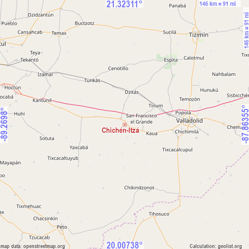
Chichén-Itzá GPS coordinates[2]
20° 40' 0.012" North, 88° 34' 0.012" West
| Map corner | latitude | longitude |
|---|---|---|
| Upper-left | 21.32311°, | -89.2698° |
| Center: | 20.66667°, | -88.56667° |
| Lower-right: | 20.00738°, | -87.86355° |
| Map W x H: | 146.3×146.3 km | = 90.9×90.9mi |
| max Lat: | 32.7° ⇑28.8% North |
| Chichén-Itzá: | 20.66667° |
| min Lat: | ⇓71.2% South 14.53588° |
| min Long | Chichén-Itzá | max Long |
| -117.105° | -88.56667° | -86.73105° |
| W 99.2%⇐ | ⇒0.8% E |
Elevation
Elevation of Chichén-Itzá is 27 m = 89 ft, and this is 1226.7 m = 4025 ft below average elevation for this country.
| Max E: |
3497 m = 11473 ft | 89% |
| Avg. | 1253.7 m = 4113 ft | |
| Chichén-Itzá | 27 m = 89 ft | |
Min E: |
-1 m = -3 ft | 11% |
See also: Mexico elevation on elevation.city.
Geographical zone
Chichén-Itzá is located in North Torrid zone (between Equator and Tropic of Cancer). Distance of this Northern Tropic circle is 308 km =191.4 mi to North.| Distance of | km | miles | from Chichén-Itzá |
|---|---|---|---|
| North Pole | 7709.1 | 4790.2 | to North |
| Arctic Circle | 5103.3 | 3171 | to North |
| Tropic Cancer | 308 | 191.4 | to North |
| Equator | 2297.9 | 1427.8 | to South |


Nearby cities:
15 places around Chichén-Itzá: (largest is in red/bold)
• Dzitás
19.8 km =12.3 mi,  11°
11°
• Kancabdzonot
23 km =14.3 mi,  220°
220°
• Kaua
16.5 km =10.3 mi,  107°
107°
• Libre Unión
25.7 km =16 mi,  279°
279°
• Piste
4.3 km =2.7 mi,  327°
327°
• Quintana Roo
23.5 km =14.6 mi,  343°
343°
• San Francisco Grande
10.4 km =6.5 mi,  68°
68°
• Ticimul
7.8 km =4.8 mi,  168°
168°
• Tinum
21.4 km =13.3 mi,  58°
58°
• Tohopkú
10.7 km =6.6 mi,  97°
97°
• Xcalak Dzonot
25.2 km =15.7 mi,  180°
180°
• Xcopteil
17.1 km =10.6 mi,  185°
185°
• Xocempich
11.7 km =7.3 mi,  357°
357°
• Yaxunah
18 km =11.2 mi, 219°
• Yokdzonot
17.9 km =11.1 mi,  285°
285°
Sources, notices
• [Note1] Compared only with cities in Mexico existing in our database
• [Src1] Map data: © OpenStreetMap contributors (CC-BY-SA)
• [Src2] Other city data from geonames.org with taken over terms of usage.
• [Src3] Geographical zone / Annual Mean Temperature by Robert A. Rohde @ Wikipedia
