Tinum geodata
Tinum (Yucatán) is a seat of a second-order administrative division; located in Mexico in America/Merida (GMT-6) time zone. With population of 2,111 people, there are 4140 cities with bigger population in this country. Compared to other cities in Mexico, 72.8% of cities are located further ↓South; 99.4% of cities are located further ←West and 88.3% of cities have higher elevation than Tinum. Note1


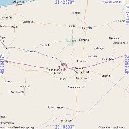
Tinum GPS coordinates[2]
20° 46' 4.044" North, 88° 23' 29.904" West
| Map corner | latitude | longitude |
|---|---|---|
| Upper-left | 21.42379°, | -89.09477° |
| Center: | 20.76779°, | -88.39164° |
| Lower-right: | 20.10893°, | -87.68852° |
| Map W x H: | 146.2×146.2 km | = 90.8×90.8mi |
| max Lat: | 32.7° ⇑27.2% North |
| Tinum: | 20.76779° |
| min Lat: | ⇓72.8% South 14.53588° |
| min Long | Tinum | max Long |
| -117.105° | -88.39164° | -86.73105° |
| W 99.4%⇐ | ⇒0.59999999999999% E |
Elevation
Elevation of Tinum is 29 m = 95 ft, and this is 1224.7 m = 4018 ft below average elevation for this country.
| Max E: |
3497 m = 11473 ft | 88.3% |
| Avg. | 1253.7 m = 4113 ft | |
| Tinum | 29 m = 95 ft | |
Min E: |
-1 m = -3 ft | 11.7% |
See also: Mexico elevation on elevation.city.
Geographical zone
Tinum is located in North Torrid zone (between Equator and Tropic of Cancer). Distance of this Northern Tropic circle is 296.8 km =184.4 mi to North.| Distance of | km | miles | from Tinum |
|---|---|---|---|
| North Pole | 7697.9 | 4783.3 | to North |
| Arctic Circle | 5092 | 3164 | to North |
| Tropic Cancer | 296.8 | 184.4 | to North |
| Equator | 2309.2 | 1434.9 | to South |


Nearby cities:
15 places around Tinum: (largest is in red/bold)
• Chichén-Itzá
21.4 km =13.3 mi,  238°
238°
• Cuncunul
17.2 km =10.7 mi,  145°
145°
• Dzitnup
20.3 km =12.6 mi,  131°
131°
• Dzitás
16.4 km =10.2 mi,  299°
299°
• Ebtun
17.9 km =11.1 mi, 129°
• Kaua
16.4 km =10.2 mi,  188°
188°
• Kunche
18.4 km =11.4 mi,  30°
30°
• Nacuche
20.1 km =12.5 mi, 29°
• Pixoy
14.4 km =8.9 mi,  113°
113°
• Popola
16.5 km =10.3 mi,  103°
103°
• San Francisco Grande
11.3 km =7 mi,  228°
228°
• Temozon
20.2 km =12.6 mi,  78°
78°
• Tohopkú
14.8 km =9.2 mi,  211°
211°
• Uayma
9.6 km =6 mi, 125°
• Xocempich
18.7 km =11.6 mi,  271°
271°
Sources, notices
• [Note1] Compared only with cities in Mexico existing in our database
• [Src1] Map data: © OpenStreetMap contributors (CC-BY-SA)
• [Src2] Other city data from geonames.org with taken over terms of usage.
• [Src3] Geographical zone / Annual Mean Temperature by Robert A. Rohde @ Wikipedia
