Yokdzonot geodata
Yokdzonot (Yucatán) is a populated place; located in Mexico in America/Merida (GMT-6) time zone. With population of 772 people, there are 11323 cities with bigger population in this country. Compared to other cities in Mexico, 71.8% of cities are located further ↓South; 99% of cities are located further ←West and 88.6% of cities have higher elevation than Yokdzonot. Note1


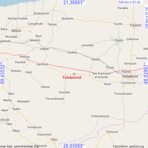
Yokdzonot GPS coordinates[2]
20° 42' 35.28" North, 88° 43' 55.884" West
| Map corner | latitude | longitude |
|---|---|---|
| Upper-left | 21.36605°, | -89.43532° |
| Center: | 20.7098°, | -88.73219° |
| Lower-right: | 20.05069°, | -88.02907° |
| Map W x H: | 146.3×146.3 km | = 90.9×90.9mi |
| max Lat: | 32.7° ⇑28.2% North |
| Yokdzonot: | 20.7098° |
| min Lat: | ⇓71.8% South 14.53588° |
| min Long | Yokdzonot | max Long |
| -117.105° | -88.73219° | -86.73105° |
| W 99%⇐ | ⇒1% E |
Elevation
Elevation of Yokdzonot is 28 m = 92 ft, and this is 1225.7 m = 4021 ft below average elevation for this country.
| Max E: |
3497 m = 11473 ft | 88.6% |
| Avg. | 1253.7 m = 4113 ft | |
| Yokdzonot | 28 m = 92 ft | |
Min E: |
-1 m = -3 ft | 11.4% |
See also: Mexico elevation on elevation.city.
Geographical zone
Yokdzonot is located in North Torrid zone (between Equator and Tropic of Cancer). Distance of this Northern Tropic circle is 303.2 km =188.4 mi to North.| Distance of | km | miles | from Yokdzonot |
|---|---|---|---|
| North Pole | 7704.3 | 4787.2 | to North |
| Arctic Circle | 5098.5 | 3168.1 | to North |
| Tropic Cancer | 303.2 | 188.4 | to North |
| Equator | 2302.7 | 1430.8 | to South |


Nearby cities:
15 places around Yokdzonot: (largest is in red/bold)
• Chichén-Itzá
17.9 km =11.1 mi,  105°
105°
• Dzitás
25.7 km =16 mi,  55°
55°
• Holca
21.1 km =13.1 mi,  284°
284°
• Kancabdzonot
22.4 km =13.9 mi,  174°
174°
• Libre Unión
8.1 km =5 mi,  267°
267°
• Piste
14.9 km =9.3 mi,  94°
94°
• Quintana Roo
20.6 km =12.8 mi,  30°
30°
• San Francisco Grande
26.9 km =16.7 mi, 92°
• Tabi
21.3 km =13.2 mi,  234°
234°
• Tibolón
22.1 km =13.7 mi,  257°
257°
• Ticimul
22.5 km =14 mi,  123°
123°
• Tunkas
21.6 km =13.4 mi,  354°
354°
• Xocempich
18.1 km =11.2 mi,  67°
67°
• Yaxcabá
20.5 km =12.7 mi,  208°
208°
• Yaxunah
19.6 km =12.2 mi,  162°
162°
Sources, notices
• [Note1] Compared only with cities in Mexico existing in our database
• [Src1] Map data: © OpenStreetMap contributors (CC-BY-SA)
• [Src2] Other city data from geonames.org with taken over terms of usage.
• [Src3] Geographical zone / Annual Mean Temperature by Robert A. Rohde @ Wikipedia
