Kaua geodata
Kaua (Yucatán) is a populated place; located in Mexico in America/Merida (GMT-6) time zone. With population of 2,340 people, there are 3772 cities with bigger population in this country. Compared to other cities in Mexico, 70.4% of cities are located further ↓South; 99.3% of cities are located further ←West and 88% of cities have higher elevation than Kaua. Note1


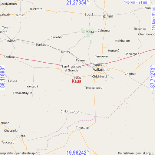
Kaua GPS coordinates[2]
20° 37' 18.84" North, 88° 24' 57.06" West
| Map corner | latitude | longitude |
|---|---|---|
| Upper-left | 21.27854°, | -89.11898° |
| Center: | 20.6219°, | -88.41585° |
| Lower-right: | 19.96242°, | -87.71273° |
| Map W x H: | 146.3×146.3 km | = 90.9×90.9mi |
| max Lat: | 32.7° ⇑29.6% North |
| Kaua: | 20.6219° |
| min Lat: | ⇓70.4% South 14.53588° |
| min Long | Kaua | max Long |
| -117.105° | -88.41585° | -86.73105° |
| W 99.3%⇐ | ⇒0.7% E |
Elevation
Elevation of Kaua is 30 m = 98 ft, and this is 1223.7 m = 4015 ft below average elevation for this country.
| Max E: |
3497 m = 11473 ft | 88% |
| Avg. | 1253.7 m = 4113 ft | |
| Kaua | 30 m = 98 ft | |
Min E: |
-1 m = -3 ft | 12% |
See also: Mexico elevation on elevation.city.
Geographical zone
Kaua is located in North Torrid zone (between Equator and Tropic of Cancer). Distance of this Northern Tropic circle is 313 km =194.5 mi to North.| Distance of | km | miles | from Kaua |
|---|---|---|---|
| North Pole | 7714.1 | 4793.3 | to North |
| Arctic Circle | 5108.2 | 3174.1 | to North |
| Tropic Cancer | 313 | 194.5 | to North |
| Equator | 2292.9 | 1424.7 | to South |


Nearby cities:
15 places around Kaua: (largest is in red/bold)
• Chichimila
20.7 km =12.9 mi,  86°
86°
• Chichén-Itzá
16.5 km =10.3 mi,  287°
287°
• Cuncunul
12.5 km =7.8 mi,  80°
80°
• Dzitnup
18 km =11.2 mi, 81°
• Ebtun
16.9 km =10.5 mi,  73°
73°
• Piste
20 km =12.4 mi,  295°
295°
• Pixoy
18.9 km =11.7 mi,  56°
56°
• San Francisco Grande
10.6 km =6.6 mi,  325°
325°
• Tekom
15.8 km =9.8 mi,  97°
97°
• Ticimul
14.4 km =8.9 mi,  259°
259°
• Tinum
16.4 km =10.2 mi,  8°
8°
• Tixcacalcupul
17.9 km =11.1 mi,  122°
122°
• Tohopkú
6.2 km =3.9 mi,  305°
305°
• Uayma
14.8 km =9.2 mi,  43°
43°
• Xcopteil
21.1 km =13.1 mi,  235°
235°
Sources, notices
• [Note1] Compared only with cities in Mexico existing in our database
• [Src1] Map data: © OpenStreetMap contributors (CC-BY-SA)
• [Src2] Other city data from geonames.org with taken over terms of usage.
• [Src3] Geographical zone / Annual Mean Temperature by Robert A. Rohde @ Wikipedia
