Piste geodata
Piste (Yucatán) is a populated place; located in Mexico in America/Merida (GMT-6) time zone. With population of 5,528 people, there are 1687 cities with bigger population in this country. Compared to other cities in Mexico, 71.6% of cities are located further ↓South; 99.1% of cities are located further ←West and 89.7% of cities have higher elevation than Piste. Note1


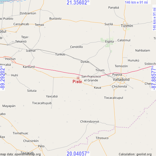
Piste GPS coordinates[2]
20° 41' 58.992" North, 88° 35' 20.004" West
| Map corner | latitude | longitude |
|---|---|---|
| Upper-left | 21.35602°, | -89.29202° |
| Center: | 20.69972°, | -88.58889° |
| Lower-right: | 20.04057°, | -87.88577° |
| Map W x H: | 146.3×146.3 km | = 90.9×90.9mi |
| max Lat: | 32.7° ⇑28.4% North |
| Piste: | 20.69972° |
| min Lat: | ⇓71.6% South 14.53588° |
| min Long | Piste | max Long |
| -117.105° | -88.58889° | -86.73105° |
| W 99.1%⇐ | ⇒0.90000000000001% E |
Elevation
Elevation of Piste is 25 m = 82 ft, and this is 1228.7 m = 4031 ft below average elevation for this country.
| Max E: |
3497 m = 11473 ft | 89.7% |
| Avg. | 1253.7 m = 4113 ft | |
| Piste | 25 m = 82 ft | |
Min E: |
-1 m = -3 ft | 10.3% |
See also: Mexico elevation on elevation.city.
Geographical zone
Piste is located in North Torrid zone (between Equator and Tropic of Cancer). Distance of this Northern Tropic circle is 304.3 km =189.1 mi to North.| Distance of | km | miles | from Piste |
|---|---|---|---|
| North Pole | 7705.5 | 4788 | to North |
| Arctic Circle | 5099.6 | 3168.7 | to North |
| Tropic Cancer | 304.3 | 189.1 | to North |
| Equator | 2301.6 | 1430.1 | to South |


Nearby cities:
15 places around Piste: (largest is in red/bold)
• Chichén-Itzá
4.3 km =2.7 mi,  147°
147°
• Dzitás
16.9 km =10.5 mi,  21°
21°
• Kancabdzonot
24.7 km =15.3 mi,  210°
210°
• Kaua
20 km =12.4 mi,  115°
115°
• Libre Unión
23 km =14.3 mi,  271°
271°
• Quintana Roo
19.4 km =12.1 mi,  346°
346°
• San Francisco Grande
12 km =7.5 mi,  89°
89°
• Ticimul
12 km =7.5 mi,  161°
161°
• Tinum
21.9 km =13.6 mi,  69°
69°
• Tohopkú
13.9 km =8.6 mi,  111°
111°
• Tunkas
28.2 km =17.5 mi,  323°
323°
• Xcopteil
20.7 km =12.9 mi,  177°
177°
• Xocempich
8.2 km =5.1 mi,  12°
12°
• Yaxunah
19.8 km =12.3 mi, 207°
• Yokdzonot
14.9 km =9.3 mi, 274°
Sources, notices
• [Note1] Compared only with cities in Mexico existing in our database
• [Src1] Map data: © OpenStreetMap contributors (CC-BY-SA)
• [Src2] Other city data from geonames.org with taken over terms of usage.
• [Src3] Geographical zone / Annual Mean Temperature by Robert A. Rohde @ Wikipedia
