Chenalhó geodata
Chenalhó (Chiapas) is a seat of a second-order administrative division; located in Mexico in America/Mexico_City (GMT-6) time zone. With population of 3,143 people, there are 2873 cities with bigger population in this country. Compared to other cities in Mexico, 90.4% of cities are located further ↑North; 91% of cities are located further ←West and 52.1% of cities have lower elevation than Chenalhó. Note1


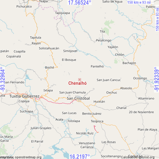
Chenalhó GPS coordinates[2]
16° 53' 37.212" North, 92° 37' 35.436" West
| Map corner | latitude | longitude |
|---|---|---|
| Upper-left | 17.56524°, | -93.32964° |
| Center: | 16.89367°, | -92.62651° |
| Lower-right: | 16.2197°, | -91.92339° |
| Map W x H: | 149.6×149.6 km | = 93×93mi |
| max Lat: | 32.7° ⇑90.4% North |
| Chenalhó: | 16.89367° |
| min Lat: | ⇓9.6% South 14.53588° |
| min Long | Chenalhó | max Long |
| -117.105° | -92.62651° | -86.73105° |
| W 91%⇐ | ⇒9% E |
Elevation
Elevation of Chenalhó is 1526 m = 5007 ft, and this is 272.3 m = 893 ft above average elevation for this country.
| Max E: |
3497 m = 11473 ft | 47.9% |
| Chenalhó | 1526 m 5007 ft | |
| Avg. | 1253.7 m = 4113 ft | |
Min E: |
-1 m = -3 ft | 52.1% |
See also: Mexico elevation on elevation.city.
Geographical zone
Chenalhó is located in North Torrid zone (between Equator and Tropic of Cancer). Distance of this Northern Tropic circle is 727.5 km =452 mi to North.| Distance of | km | miles | from Chenalhó |
|---|---|---|---|
| North Pole | 8128.7 | 5050.9 | to North |
| Arctic Circle | 5522.8 | 3431.7 | to North |
| Tropic Cancer | 727.5 | 452 | to North |
| Equator | 1878.4 | 1167.2 | to South |


Nearby cities:
15 places around Chenalhó: (largest is in red/bold)
• Bashequen
2 km =1.2 mi,  120°
120°
• Belisario Domínguez
3.6 km =2.2 mi,  266°
266°
• Caridad San Antonio
4.9 km =3 mi,  313°
313°
• Chicumtantic
3.9 km =2.4 mi,  144°
144°
• Chiotic
5.1 km =3.2 mi,  177°
177°
• Cuchumtón
5.1 km =3.2 mi, 118°
• Icalumtic
4.7 km =2.9 mi,  225°
225°
• La Libertad
6.5 km =4 mi,  79°
79°
• Majomut
6.1 km =3.8 mi,  215°
215°
• Mitontic
3 km =1.9 mi, 183°
• Suyalhó
5.5 km =3.4 mi,  105°
105°
• Tzajalchén
6.6 km =4.1 mi,  198°
198°
• Tzoeptic
6.3 km =3.9 mi,  101°
101°
• Yaxalumil
6 km =3.7 mi,  61°
61°
• Yitic
4.1 km =2.5 mi, 179°
Sources, notices
• [Note1] Compared only with cities in Mexico existing in our database
• [Src1] Map data: © OpenStreetMap contributors (CC-BY-SA)
• [Src2] Other city data from geonames.org with taken over terms of usage.
• [Src3] Geographical zone / Annual Mean Temperature by Robert A. Rohde @ Wikipedia
