Tzajalchén geodata
Tzajalchén (Chiapas) is a populated place; located in Mexico in America/Mexico_City (GMT-6) time zone. With population of 635 people, there are 13639 cities with bigger population in this country. Compared to other cities in Mexico, 91.2% of cities are located further ↑North; 90.8% of cities are located further ←West and 73.9% of cities have lower elevation than Tzajalchén. Note1


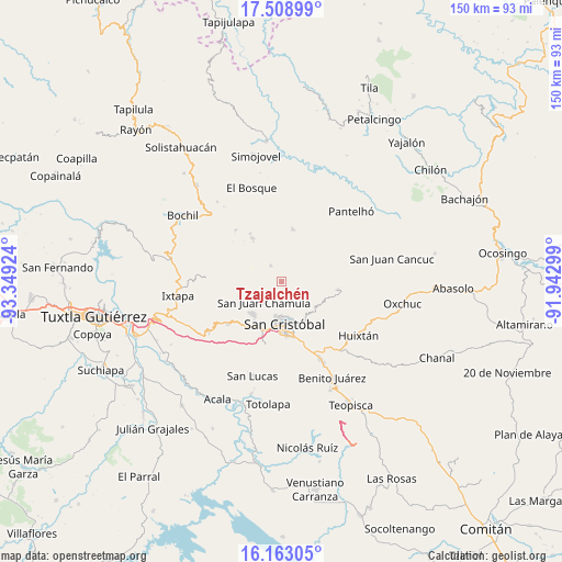
Tzajalchén GPS coordinates[2]
16° 50' 13.992" North, 92° 38' 45.996" West
| Map corner | latitude | longitude |
|---|---|---|
| Upper-left | 17.50899°, | -93.34924° |
| Center: | 16.83722°, | -92.64611° |
| Lower-right: | 16.16305°, | -91.94299° |
| Map W x H: | 149.7×149.7 km | = 93×93mi |
| max Lat: | 32.7° ⇑91.2% North |
| Tzajalchén: | 16.83722° |
| min Lat: | ⇓8.8% South 14.53588° |
| min Long | Tzajalchén | max Long |
| -117.105° | -92.64611° | -86.73105° |
| W 90.8%⇐ | ⇒9.2% E |
Elevation
Elevation of Tzajalchén is 2010 m = 6594 ft, and this is 756.3 m = 2481 ft above average elevation for this country.
| Max E: |
3497 m = 11473 ft | 26.1% |
| Tzajalchén | 2010 m 6594 ft | |
| Avg. | 1253.7 m = 4113 ft | |
Min E: |
-1 m = -3 ft | 73.9% |
See also: Mexico elevation on elevation.city.
Geographical zone
Tzajalchén is located in North Torrid zone (between Equator and Tropic of Cancer). Distance of this Northern Tropic circle is 733.8 km =456 mi to North.| Distance of | km | miles | from Tzajalchén |
|---|---|---|---|
| North Pole | 8134.9 | 5054.8 | to North |
| Arctic Circle | 5529.1 | 3435.6 | to North |
| Tropic Cancer | 733.8 | 456 | to North |
| Equator | 1872.1 | 1163.3 | to South |


Nearby cities:
15 places around Tzajalchén: (largest is in red/bold)
• Chicumtantic
5.4 km =3.4 mi,  54°
54°
• Chicviltenal
2.4 km =1.5 mi,  235°
235°
• Chiotic
2.5 km =1.6 mi,  63°
63°
• Cruz Quemada
5.3 km =3.3 mi,  254°
254°
• Icalumtic
3.3 km =2.1 mi,  336°
336°
• Joltzemén
4.3 km =2.7 mi,  141°
141°
• Majomut
1.9 km =1.2 mi,  313°
313°
• Mitontic
3.8 km =2.4 mi,  30°
30°
• Muquén
5.1 km =3.2 mi,  131°
131°
• Pilalchén
4.2 km =2.6 mi,  275°
275°
• Shucutón
0.9 km =0.6 mi,  208°
208°
• Tentic
4.8 km =3 mi, 307°
• Yitic
3.1 km =1.9 mi,  43°
43°
• Yolonan
3.2 km =2 mi,  105°
105°
• Yutniotic
1.6 km =1 mi,  180°
180°
Sources, notices
• [Note1] Compared only with cities in Mexico existing in our database
• [Src1] Map data: © OpenStreetMap contributors (CC-BY-SA)
• [Src2] Other city data from geonames.org with taken over terms of usage.
• [Src3] Geographical zone / Annual Mean Temperature by Robert A. Rohde @ Wikipedia
