Chalahuite geodata
Chalahuite (Veracruz) is a populated place; located in Mexico in America/Mexico_City (GMT-6) time zone. With population of 534 people, there are 15868 cities with bigger population in this country. Compared to other cities in Mexico, 77.4% of cities are located further ↓South; 69% of cities are located further ←West and 84.3% of cities have higher elevation than Chalahuite. Note1


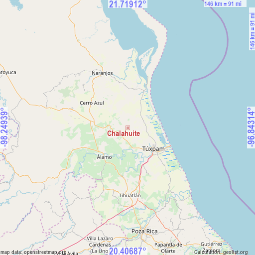
Chalahuite GPS coordinates[2]
21° 3' 51.984" North, 97° 32' 46.536" West
| Map corner | latitude | longitude |
|---|---|---|
| Upper-left | 21.71912°, | -98.24939° |
| Center: | 21.06444°, | -97.54626° |
| Lower-right: | 20.40687°, | -96.84314° |
| Map W x H: | 145.9×145.9 km | = 90.7×90.7mi |
| max Lat: | 32.7° ⇑22.6% North |
| Chalahuite: | 21.06444° |
| min Lat: | ⇓77.4% South 14.53588° |
| min Long | Chalahuite | max Long |
| -117.105° | -97.54626° | -86.73105° |
| W 69%⇐ | ⇒31% E |
Elevation
Elevation of Chalahuite is 50 m = 164 ft, and this is 1203.7 m = 3949 ft below average elevation for this country.
| Max E: |
3497 m = 11473 ft | 84.3% |
| Avg. | 1253.7 m = 4113 ft | |
| Chalahuite | 50 m = 164 ft | |
Min E: |
-1 m = -3 ft | 15.7% |
See also: Mexico elevation on elevation.city.
Geographical zone
Chalahuite is located in North Torrid zone (between Equator and Tropic of Cancer). Distance of this Northern Tropic circle is 263.8 km =163.9 mi to North.| Distance of | km | miles | from Chalahuite |
|---|---|---|---|
| North Pole | 7664.9 | 4762.7 | to North |
| Arctic Circle | 5059 | 3143.5 | to North |
| Tropic Cancer | 263.8 | 163.9 | to North |
| Equator | 2342.1 | 1455.3 | to South |


Nearby cities:
15 places around Chalahuite: (largest is in red/bold)
• Alto Lucero
16.4 km =10.2 mi,  138°
138°
• Banderas
17.8 km =11.1 mi,  117°
117°
• Buenos Aires
12.8 km =8 mi,  157°
157°
• Colonia México Lindo
15.5 km =9.6 mi, 144°
• Cruz Naranjos
14.9 km =9.3 mi,  132°
132°
• Doctor Montes de Oca
14.5 km =9 mi,  183°
183°
• Higueral
13.1 km =8.1 mi, 157°
• Kilómetro Treinta y Tres (Paso Real)
18.6 km =11.6 mi,  195°
195°
• Ojite Rancho Nuevo
10.7 km =6.6 mi,  169°
169°
• San Miguel
12.8 km =8 mi, 180°
• Temapache
9.9 km =6.2 mi,  271°
271°
• Tumbadero
14.1 km =8.8 mi,  193°
193°
• Túxpam de Rodríguez Cano
18.6 km =11.6 mi, 129°
• Vara Alta
15.4 km =9.6 mi,  240°
240°
• Villa Hermosa
12.5 km =7.8 mi, 199°
Sources, notices
• [Note1] Compared only with cities in Mexico existing in our database
• [Src1] Map data: © OpenStreetMap contributors (CC-BY-SA)
• [Src2] Other city data from geonames.org with taken over terms of usage.
• [Src3] Geographical zone / Annual Mean Temperature by Robert A. Rohde @ Wikipedia
