Villa Hermosa geodata
Villa Hermosa (Veracruz) is a populated place; located in Mexico in America/Mexico_City (GMT-6) time zone. With population of 555 people, there are 15371 cities with bigger population in this country. Compared to other cities in Mexico, 75.9% of cities are located further ↓South; 68.6% of cities are located further ←West and 84.3% of cities have higher elevation than Villa Hermosa. Note1


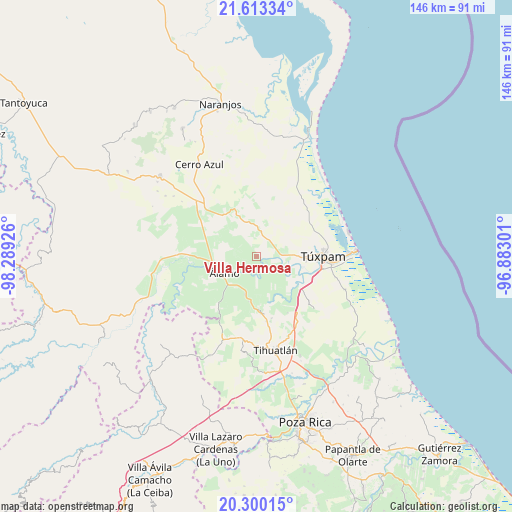
Villa Hermosa GPS coordinates[2]
20° 57' 29.484" North, 97° 35' 10.068" West
| Map corner | latitude | longitude |
|---|---|---|
| Upper-left | 21.61334°, | -98.28926° |
| Center: | 20.95819°, | -97.58613° |
| Lower-right: | 20.30015°, | -96.88301° |
| Map W x H: | 146×146 km | = 90.7×90.7mi |
| max Lat: | 32.7° ⇑24.1% North |
| Villa Hermosa: | 20.95819° |
| min Lat: | ⇓75.9% South 14.53588° |
| min Long | Villa Hermosa | max Long |
| -117.105° | -97.58613° | -86.73105° |
| W 68.6%⇐ | ⇒31.4% E |
Elevation
Elevation of Villa Hermosa is 49 m = 161 ft, and this is 1204.7 m = 3952 ft below average elevation for this country.
| Max E: |
3497 m = 11473 ft | 84.3% |
| Avg. | 1253.7 m = 4113 ft | |
| Villa Hermosa | 49 m = 161 ft | |
Min E: |
-1 m = -3 ft | 15.7% |
See also: Mexico elevation on elevation.city.
Geographical zone
Villa Hermosa is located in North Torrid zone (between Equator and Tropic of Cancer). Distance of this Northern Tropic circle is 275.6 km =171.2 mi to North.| Distance of | km | miles | from Villa Hermosa |
|---|---|---|---|
| North Pole | 7676.7 | 4770.1 | to North |
| Arctic Circle | 5070.8 | 3150.8 | to North |
| Tropic Cancer | 275.6 | 171.2 | to North |
| Equator | 2330.3 | 1448 | to South |


Nearby cities:
15 places around Villa Hermosa: (largest is in red/bold)
• Buenos Aires
8.9 km =5.5 mi,  90°
90°
• Chapopote Núñez
10.5 km =6.5 mi,  253°
253°
• Citlaltépetl
10.7 km =6.6 mi,  192°
192°
• Doctor Montes de Oca
4.1 km =2.5 mi,  129°
129°
• Hidalgo Amajac
7.4 km =4.6 mi,  217°
217°
• Higueral
9.1 km =5.7 mi, 92°
• Jardín Viejo
8.6 km =5.3 mi,  232°
232°
• Kilómetro Treinta y Tres (Paso Real)
6.2 km =3.9 mi, 187°
• Loma Bonita
9.7 km =6 mi,  257°
257°
• Ojite Rancho Nuevo
6.2 km =3.9 mi,  78°
78°
• Raudal Nuevo
8.6 km =5.3 mi,  177°
177°
• San Miguel
4.2 km =2.6 mi,  103°
103°
• Tumbadero
2 km =1.2 mi,  156°
156°
• Vara Alta
10.1 km =6.3 mi,  294°
294°
• Álamo
10.6 km =6.6 mi,  240°
240°
Sources, notices
• [Note1] Compared only with cities in Mexico existing in our database
• [Src1] Map data: © OpenStreetMap contributors (CC-BY-SA)
• [Src2] Other city data from geonames.org with taken over terms of usage.
• [Src3] Geographical zone / Annual Mean Temperature by Robert A. Rohde @ Wikipedia
