Ojite Rancho Nuevo geodata
Ojite Rancho Nuevo (Veracruz) is a populated place; located in Mexico in America/Mexico_City (GMT-6) time zone. With population of 1,116 people, there are 7786 cities with bigger population in this country. Compared to other cities in Mexico, 76% of cities are located further ↓South; 69.3% of cities are located further ←West and 86.3% of cities have higher elevation than Ojite Rancho Nuevo. Note1


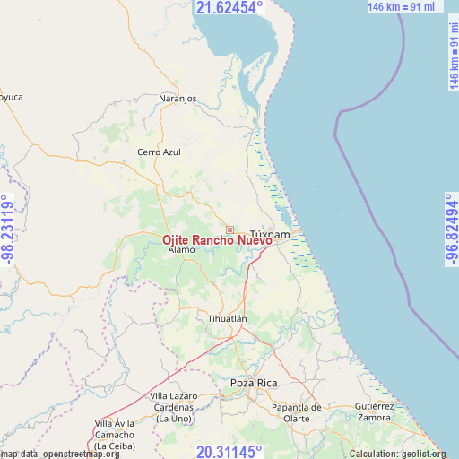
Ojite Rancho Nuevo GPS coordinates[2]
20° 58' 9.984" North, 97° 31' 41.016" West
| Map corner | latitude | longitude |
|---|---|---|
| Upper-left | 21.62454°, | -98.23119° |
| Center: | 20.96944°, | -97.52806° |
| Lower-right: | 20.31145°, | -96.82494° |
| Map W x H: | 146×146 km | = 90.7×90.7mi |
| max Lat: | 32.7° ⇑24% North |
| Ojite Rancho Nuevo: | 20.96944° |
| min Lat: | ⇓76% South 14.53588° |
| min Long | Ojite Rancho Nu | max Long |
| -117.105° | -97.52806° | -86.73105° |
| W 69.3%⇐ | ⇒30.7% E |
Elevation
Elevation of Ojite Rancho Nuevo is 37 m = 121 ft, and this is 1216.7 m = 3992 ft below average elevation for this country.
| Max E: |
3497 m = 11473 ft | 86.3% |
| Avg. | 1253.7 m = 4113 ft | |
| Ojite Rancho Nuevo | 37 m = 121 ft | |
Min E: |
-1 m = -3 ft | 13.7% |
See also: Mexico elevation on elevation.city.
Geographical zone
Ojite Rancho Nuevo is located in North Torrid zone (between Equator and Tropic of Cancer). Distance of this Northern Tropic circle is 274.3 km =170.4 mi to North.| Distance of | km | miles | from Ojite Rancho Nuevo |
|---|---|---|---|
| North Pole | 7675.5 | 4769.3 | to North |
| Arctic Circle | 5069.6 | 3150.1 | to North |
| Tropic Cancer | 274.3 | 170.4 | to North |
| Equator | 2331.6 | 1448.8 | to South |


Nearby cities:
15 places around Ojite Rancho Nuevo: (largest is in red/bold)
• Alto Lucero
9.1 km =5.7 mi,  101°
101°
• Buenos Aires
3.2 km =2 mi,  113°
113°
• Chalahuite
10.7 km =6.6 mi,  349°
349°
• Colonia México Lindo
7.3 km =4.5 mi, 106°
• Cruz Naranjos
9.1 km =5.7 mi,  86°
86°
• Doctor Montes de Oca
4.8 km =3 mi,  216°
216°
• Hidalgo Amajac
12.7 km =7.9 mi,  235°
235°
• Higueral
3.4 km =2.1 mi,  117°
117°
• Kilómetro Treinta y Tres (Paso Real)
10.1 km =6.3 mi, 222°
• Raudal Nuevo
11.3 km =7 mi,  209°
209°
• San Miguel
3 km =1.9 mi, 221°
• Tierra Blanca
12.7 km =7.9 mi,  146°
146°
• Tumbadero
6.1 km =3.8 mi, 239°
• Túxpam de Rodríguez Cano
12.5 km =7.8 mi, 95°
• Villa Hermosa
6.2 km =3.9 mi,  258°
258°
Sources, notices
• [Note1] Compared only with cities in Mexico existing in our database
• [Src1] Map data: © OpenStreetMap contributors (CC-BY-SA)
• [Src2] Other city data from geonames.org with taken over terms of usage.
• [Src3] Geographical zone / Annual Mean Temperature by Robert A. Rohde @ Wikipedia
