Celestún geodata
Celestún (Yucatán) is a seat of a second-order administrative division; located in Mexico in America/Merida (GMT-6) time zone. With population of 6,810 people, there are 1371 cities with bigger population in this country. Compared to other cities in Mexico, 74.1% of cities are located further ↓South; 97.2% of cities are located further ←West and 99.6% of cities have higher elevation than Celestún. Note1


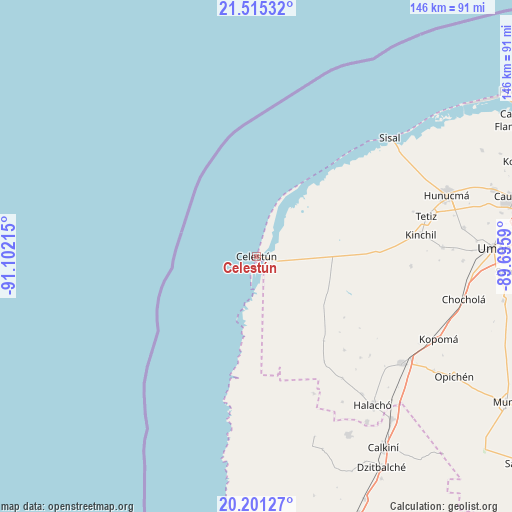
Celestún GPS coordinates[2]
20° 51' 35.028" North, 90° 23' 56.472" West
| Map corner | latitude | longitude |
|---|---|---|
| Upper-left | 21.51532°, | -91.10215° |
| Center: | 20.85973°, | -90.39902° |
| Lower-right: | 20.20127°, | -89.6959° |
| Map W x H: | 146.1×146.1 km | = 90.8×90.8mi |
| max Lat: | 32.7° ⇑25.9% North |
| Celestún: | 20.85973° |
| min Lat: | ⇓74.1% South 14.53588° |
| min Long | Celestún | max Long |
| -117.105° | -90.39902° | -86.73105° |
| W 97.2%⇐ | ⇒2.8% E |
Elevation
Elevation of Celestún is 4 m = 13 ft, and this is 1249.7 m = 4100 ft below average elevation for this country.
| Max E: |
3497 m = 11473 ft | 99.6% |
| Avg. | 1253.7 m = 4113 ft | |
| Celestún | 4 m = 13 ft | |
Min E: |
-1 m = -3 ft | 0.4% |
See also: Mexico elevation on elevation.city.
Geographical zone
Celestún is located in North Torrid zone (between Equator and Tropic of Cancer). Distance of this Northern Tropic circle is 286.5 km =178 mi to North.| Distance of | km | miles | from Celestún |
|---|---|---|---|
| North Pole | 7687.7 | 4776.9 | to North |
| Arctic Circle | 5081.8 | 3157.7 | to North |
| Tropic Cancer | 286.5 | 178 | to North |
| Equator | 2319.4 | 1441.2 | to South |


Nearby cities:
15 places around Celestún: (largest is in red/bold)
• Cepeda
49.5 km =30.8 mi,  142°
142°
• Chunchucmil
30.8 km =19.1 mi, 141°
• Coahuila
32.1 km =19.9 mi,  132°
132°
• Dzidzibachi
42.9 km =26.7 mi, 138°
• Isla Arena
19.6 km =12.2 mi,  196°
196°
• Kinchil
47.2 km =29.3 mi,  82°
82°
• Kochol
36.6 km =22.7 mi, 137°
• Nohuayun
46.5 km =28.9 mi,  73°
73°
• Paraíso
35.8 km =22.2 mi,  124°
124°
• San Antonio Tedzidz
44.1 km =27.4 mi,  93°
93°
• San Rafael
30.5 km =19 mi, 124°
• Santa María Acú
42.6 km =26.5 mi, 144°
• Santa Rosa
42.9 km =26.7 mi, 131°
• Santo Domingo
41.2 km =25.6 mi, 134°
• Tankuché
42.5 km =26.4 mi,  157°
157°
Sources, notices
• [Note1] Compared only with cities in Mexico existing in our database
• [Src1] Map data: © OpenStreetMap contributors (CC-BY-SA)
• [Src2] Other city data from geonames.org with taken over terms of usage.
• [Src3] Geographical zone / Annual Mean Temperature by Robert A. Rohde @ Wikipedia
