Cepeda geodata
Cepeda (Yucatán) is a populated place; located in Mexico in America/Merida (GMT-6) time zone. With population of 3,064 people, there are 2940 cities with bigger population in this country. Compared to other cities in Mexico, 67.9% of cities are located further ↓South; 97.5% of cities are located further ←West and 96.3% of cities have higher elevation than Cepeda. Note1


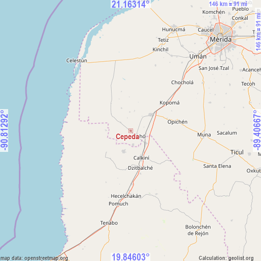
Cepeda GPS coordinates[2]
20° 30' 21.6" North, 90° 6' 35.244" West
| Map corner | latitude | longitude |
|---|---|---|
| Upper-left | 21.16314°, | -90.81292° |
| Center: | 20.506°, | -90.10979° |
| Lower-right: | 19.84603°, | -89.40667° |
| Map W x H: | 146.4×146.5 km | = 91×91mi |
| max Lat: | 32.7° ⇑32.1% North |
| Cepeda: | 20.506° |
| min Lat: | ⇓67.9% South 14.53588° |
| min Long | Cepeda | max Long |
| -117.105° | -90.10979° | -86.73105° |
| W 97.5%⇐ | ⇒2.5% E |
Elevation
Elevation of Cepeda is 11 m = 36 ft, and this is 1242.7 m = 4077 ft below average elevation for this country.
| Max E: |
3497 m = 11473 ft | 96.3% |
| Avg. | 1253.7 m = 4113 ft | |
| Cepeda | 11 m = 36 ft | |
Min E: |
-1 m = -3 ft | 3.7% |
See also: Mexico elevation on elevation.city.
Geographical zone
Cepeda is located in North Torrid zone (between Equator and Tropic of Cancer). Distance of this Northern Tropic circle is 325.9 km =202.5 mi to North.| Distance of | km | miles | from Cepeda |
|---|---|---|---|
| North Pole | 7727 | 4801.3 | to North |
| Arctic Circle | 5121.1 | 3182.1 | to North |
| Tropic Cancer | 325.9 | 202.5 | to North |
| Equator | 2280.1 | 1416.8 | to South |


Nearby cities:
15 places around Cepeda: (largest is in red/bold)
• Bécal
11.2 km =7 mi,  129°
129°
• Calkiní
16.4 km =10.2 mi,  158°
158°
• Chunchucmil
18.7 km =11.6 mi,  324°
324°
• Cuch Holoch
8.1 km =5 mi,  170°
170°
• Dzidzibachi
7.3 km =4.5 mi,  346°
346°
• Halachó
4.3 km =2.7 mi,  136°
136°
• Kochol
13.5 km =8.4 mi,  337°
337°
• Maxcanú
14.3 km =8.9 mi,  52°
52°
• Nunkiní
12.4 km =7.7 mi,  198°
198°
• Santa Cruz Ex-Hacienda
18.3 km =11.4 mi,  228°
228°
• Santa María Acú
7.2 km =4.5 mi,  308°
308°
• Santa Rosa
11.3 km =7 mi,  11°
11°
• Santo Domingo
10.5 km =6.5 mi,  356°
356°
• Tankuché
13.7 km =8.5 mi,  270°
270°
• Tepakán
14.1 km =8.8 mi,  149°
149°
Sources, notices
• [Note1] Compared only with cities in Mexico existing in our database
• [Src1] Map data: © OpenStreetMap contributors (CC-BY-SA)
• [Src2] Other city data from geonames.org with taken over terms of usage.
• [Src3] Geographical zone / Annual Mean Temperature by Robert A. Rohde @ Wikipedia
