Santa Rosa geodata
Santa Rosa (Yucatán) is a populated place; located in Mexico in America/Merida (GMT-6) time zone. With population of 913 people, there are 9556 cities with bigger population in this country. Compared to other cities in Mexico, 70.1% of cities are located further ↓South; 97.5% of cities are located further ←West and 97.5% of cities have higher elevation than Santa Rosa. Note1


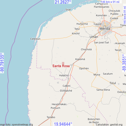
Santa Rosa GPS coordinates[2]
20° 36' 21.564" North, 90° 5' 17.592" West
| Map corner | latitude | longitude |
|---|---|---|
| Upper-left | 21.2627°, | -90.79135° |
| Center: | 20.60599°, | -90.08822° |
| Lower-right: | 19.94644°, | -89.3851° |
| Map W x H: | 146.4×146.4 km | = 91×91mi |
| max Lat: | 32.7° ⇑29.9% North |
| Santa Rosa: | 20.60599° |
| min Lat: | ⇓70.1% South 14.53588° |
| min Long | Santa Rosa | max Long |
| -117.105° | -90.08822° | -86.73105° |
| W 97.5%⇐ | ⇒2.5% E |
Elevation
Elevation of Santa Rosa is 9 m = 30 ft, and this is 1244.7 m = 4084 ft below average elevation for this country.
| Max E: |
3497 m = 11473 ft | 97.5% |
| Avg. | 1253.7 m = 4113 ft | |
| Santa Rosa | 9 m = 30 ft | |
Min E: |
-1 m = -3 ft | 2.5% |
See also: Mexico elevation on elevation.city.
Geographical zone
Santa Rosa is located in North Torrid zone (between Equator and Tropic of Cancer). Distance of this Northern Tropic circle is 314.7 km =195.5 mi to North.| Distance of | km | miles | from Santa Rosa |
|---|---|---|---|
| North Pole | 7715.9 | 4794.4 | to North |
| Arctic Circle | 5110 | 3175.2 | to North |
| Tropic Cancer | 314.7 | 195.5 | to North |
| Equator | 2291.2 | 1423.7 | to South |


Nearby cities:
15 places around Santa Rosa: (largest is in red/bold)
• Bécal
19.3 km =12 mi,  160°
160°
• Calcehtoc
18.8 km =11.7 mi,  102°
102°
• Cepeda
11.3 km =7 mi,  191°
191°
• Chunchucmil
13.7 km =8.5 mi,  287°
287°
• Coahuila
10.8 km =6.7 mi,  307°
307°
• Cuch Holoch
19.1 km =11.9 mi,  182°
182°
• Dzidzibachi
5.7 km =3.5 mi,  224°
224°
• Halachó
14.3 km =8.9 mi, 176°
• Kochol
7.5 km =4.7 mi,  280°
280°
• Maxcanú
9.4 km =5.8 mi, 104°
• Paraíso
8.3 km =5.2 mi,  338°
338°
• San Rafael
13 km =8.1 mi,  325°
325°
• Santa María Acú
10.3 km =6.4 mi,  229°
229°
• Santo Domingo
3 km =1.9 mi,  257°
257°
• Tankuché
19.4 km =12.1 mi,  235°
235°
Sources, notices
• [Note1] Compared only with cities in Mexico existing in our database
• [Src1] Map data: © OpenStreetMap contributors (CC-BY-SA)
• [Src2] Other city data from geonames.org with taken over terms of usage.
• [Src3] Geographical zone / Annual Mean Temperature by Robert A. Rohde @ Wikipedia
