Paraíso geodata
Paraíso (Yucatán) is a populated place; located in Mexico in America/Merida (GMT-6) time zone. With population of 656 people, there are 13229 cities with bigger population in this country. Compared to other cities in Mexico, 71.4% of cities are located further ↓South; 97.5% of cities are located further ←West and 96.3% of cities have higher elevation than Paraíso. Note1


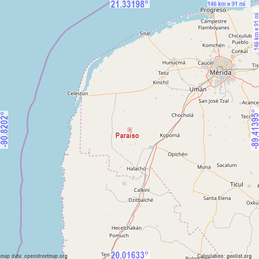
Paraíso GPS coordinates[2]
20° 40' 32.088" North, 90° 7' 1.452" West
| Map corner | latitude | longitude |
|---|---|---|
| Upper-left | 21.33198°, | -90.8202° |
| Center: | 20.67558°, | -90.11707° |
| Lower-right: | 20.01633°, | -89.41395° |
| Map W x H: | 146.3×146.3 km | = 90.9×90.9mi |
| max Lat: | 32.7° ⇑28.6% North |
| Paraíso: | 20.67558° |
| min Lat: | ⇓71.4% South 14.53588° |
| min Long | Paraíso | max Long |
| -117.105° | -90.11707° | -86.73105° |
| W 97.5%⇐ | ⇒2.5% E |
Elevation
Elevation of Paraíso is 11 m = 36 ft, and this is 1242.7 m = 4077 ft below average elevation for this country.
| Max E: |
3497 m = 11473 ft | 96.3% |
| Avg. | 1253.7 m = 4113 ft | |
| Paraíso | 11 m = 36 ft | |
Min E: |
-1 m = -3 ft | 3.7% |
See also: Mexico elevation on elevation.city.
Geographical zone
Paraíso is located in North Torrid zone (between Equator and Tropic of Cancer). Distance of this Northern Tropic circle is 307 km =190.8 mi to North.| Distance of | km | miles | from Paraíso |
|---|---|---|---|
| North Pole | 7708.2 | 4789.7 | to North |
| Arctic Circle | 5102.3 | 3170.4 | to North |
| Tropic Cancer | 307 | 190.8 | to North |
| Equator | 2298.9 | 1428.5 | to South |


Nearby cities:
15 places around Paraíso: (largest is in red/bold)
• Calcehtoc
24.4 km =15.2 mi,  119°
119°
• Cepeda
18.9 km =11.7 mi,  177°
177°
• Chunchucmil
10.7 km =6.6 mi,  250°
250°
• Coahuila
5.7 km =3.5 mi,  258°
258°
• Dzidzibachi
11.8 km =7.3 mi, 184°
• Halachó
22.3 km =13.9 mi,  170°
170°
• Kochol
7.7 km =4.8 mi,  214°
214°
• Kopoma
22.8 km =14.2 mi,  97°
97°
• Maxcanú
15.8 km =9.8 mi,  129°
129°
• San Antonio Tedzidz
23.1 km =14.4 mi,  39°
39°
• San Rafael
5.3 km =3.3 mi,  305°
305°
• Santa María Acú
15.2 km =9.4 mi,  198°
198°
• Santa Rosa
8.3 km =5.2 mi,  158°
158°
• Santo Domingo
8.4 km =5.2 mi, 179°
• Tankuché
22.8 km =14.2 mi, 214°
Sources, notices
• [Note1] Compared only with cities in Mexico existing in our database
• [Src1] Map data: © OpenStreetMap contributors (CC-BY-SA)
• [Src2] Other city data from geonames.org with taken over terms of usage.
• [Src3] Geographical zone / Annual Mean Temperature by Robert A. Rohde @ Wikipedia
