Santa María Acú geodata
Santa María Acú (Yucatán) is a populated place; located in Mexico in America/Merida (GMT-6) time zone. With population of 1,437 people, there are 6010 cities with bigger population in this country. Compared to other cities in Mexico, 68.8% of cities are located further ↓South; 97.4% of cities are located further ←West and 97% of cities have higher elevation than Santa María Acú. Note1


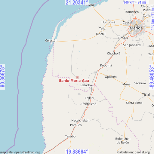
Santa María Acú GPS coordinates[2]
20° 32' 47.184" North, 90° 9' 49.14" West
| Map corner | latitude | longitude |
|---|---|---|
| Upper-left | 21.20341°, | -90.86678° |
| Center: | 20.54644°, | -90.16365° |
| Lower-right: | 19.88664°, | -89.46053° |
| Map W x H: | 146.4×146.4 km | = 91×91mi |
| max Lat: | 32.7° ⇑31.2% North |
| Santa María Acú: | 20.54644° |
| min Lat: | ⇓68.8% South 14.53588° |
| min Long | Santa María Ac | max Long |
| -117.105° | -90.16365° | -86.73105° |
| W 97.4%⇐ | ⇒2.6% E |
Elevation
Elevation of Santa María Acú is 10 m = 33 ft, and this is 1243.7 m = 4080 ft below average elevation for this country.
| Max E: |
3497 m = 11473 ft | 97% |
| Avg. | 1253.7 m = 4113 ft | |
| Santa María Acú | 10 m = 33 ft | |
Min E: |
-1 m = -3 ft | 3% |
See also: Mexico elevation on elevation.city.
Geographical zone
Santa María Acú is located in North Torrid zone (between Equator and Tropic of Cancer). Distance of this Northern Tropic circle is 321.4 km =199.7 mi to North.| Distance of | km | miles | from Santa María Acú |
|---|---|---|---|
| North Pole | 7722.5 | 4798.5 | to North |
| Arctic Circle | 5116.6 | 3179.3 | to North |
| Tropic Cancer | 321.4 | 199.7 | to North |
| Equator | 2284.5 | 1419.5 | to South |


Nearby cities:
15 places around Santa María Acú: (largest is in red/bold)
• Bécal
18.4 km =11.4 mi,  129°
129°
• Cepeda
7.2 km =4.5 mi, 128°
• Chunchucmil
12 km =7.5 mi,  333°
333°
• Coahuila
13.2 km =8.2 mi,  356°
356°
• Cuch Holoch
14.3 km =8.9 mi,  150°
150°
• Dzidzibachi
4.6 km =2.9 mi,  56°
56°
• Halachó
11.5 km =7.1 mi, 131°
• Kochol
8 km =5 mi,  3°
3°
• Maxcanú
17.5 km =10.9 mi,  75°
75°
• Nunkiní
16.3 km =10.1 mi,  174°
174°
• Paraíso
15.2 km =9.4 mi,  18°
18°
• San Rafael
17.4 km =10.8 mi, 1°
• Santa Rosa
10.3 km =6.4 mi,  49°
49°
• Santo Domingo
7.7 km =4.8 mi,  39°
39°
• Tankuché
9.2 km =5.7 mi,  241°
241°
Sources, notices
• [Note1] Compared only with cities in Mexico existing in our database
• [Src1] Map data: © OpenStreetMap contributors (CC-BY-SA)
• [Src2] Other city data from geonames.org with taken over terms of usage.
• [Src3] Geographical zone / Annual Mean Temperature by Robert A. Rohde @ Wikipedia
