Catazajá geodata
Catazajá (Chiapas) is a seat of a second-order administrative division; located in Mexico in America/Mexico_City (GMT-6) time zone. With population of 2,973 people, there are 3012 cities with bigger population in this country. Compared to other cities in Mexico, 81.1% of cities are located further ↑North; 95.2% of cities are located further ←West and 95.1% of cities have higher elevation than Catazajá. Note1


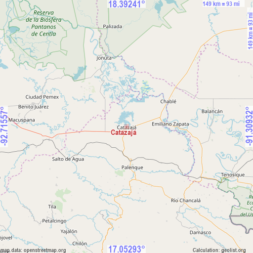
Catazajá GPS coordinates[2]
17° 43' 26.112" North, 92° 0' 44.784" West
| Map corner | latitude | longitude |
|---|---|---|
| Upper-left | 18.39241°, | -92.71557° |
| Center: | 17.72392°, | -92.01244° |
| Lower-right: | 17.05293°, | -91.30932° |
| Map W x H: | 148.9×148.9 km | = 92.5×92.5mi |
| max Lat: | 32.7° ⇑81.1% North |
| Catazajá: | 17.72392° |
| min Lat: | ⇓18.9% South 14.53588° |
| min Long | Catazajá | max Long |
| -117.105° | -92.01244° | -86.73105° |
| W 95.2%⇐ | ⇒4.8% E |
Elevation
Elevation of Catazajá is 13 m = 43 ft, and this is 1240.7 m = 4071 ft below average elevation for this country.
| Max E: |
3497 m = 11473 ft | 95.1% |
| Avg. | 1253.7 m = 4113 ft | |
| Catazajá | 13 m = 43 ft | |
Min E: |
-1 m = -3 ft | 4.9% |
See also: Mexico elevation on elevation.city.
Geographical zone
Catazajá is located in North Torrid zone (between Equator and Tropic of Cancer). Distance of this Northern Tropic circle is 635.2 km =394.7 mi to North.| Distance of | km | miles | from Catazajá |
|---|---|---|---|
| North Pole | 8036.3 | 4993.5 | to North |
| Arctic Circle | 5430.5 | 3374.4 | to North |
| Tropic Cancer | 635.2 | 394.7 | to North |
| Equator | 1970.7 | 1224.5 | to South |


Nearby cities:
15 places around Catazajá: (largest is in red/bold)
• Agua Fría
9.3 km =5.8 mi,  284°
284°
• Boca de San Jerónimo
22.6 km =14 mi,  27°
27°
• Cuauhtémoc
9.3 km =5.8 mi,  252°
252°
• El Paraíso
8.2 km =5.1 mi,  337°
337°
• El Rosario
13 km =8.1 mi,  314°
314°
• Emilio Rabasa
16.8 km =10.4 mi,  259°
259°
• Ignacio Zaragoza
7.3 km =4.5 mi,  17°
17°
• José María Morelos y Pavón Centro
21.8 km =13.5 mi,  102°
102°
• Loma Bonita
9.8 km =6.1 mi,  315°
315°
• Los Pájaros
21.7 km =13.5 mi, 341°
• Palenque
24 km =14.9 mi,  172°
172°
• Punta Arena
5.5 km =3.4 mi,  296°
296°
• Saturnino Ríos
22 km =13.7 mi,  240°
240°
• Torno Largo 2da. Sección
21.6 km =13.4 mi,  356°
356°
• Tzeltal Mukul-Já
15.6 km =9.7 mi,  218°
218°
Sources, notices
• [Note1] Compared only with cities in Mexico existing in our database
• [Src1] Map data: © OpenStreetMap contributors (CC-BY-SA)
• [Src2] Other city data from geonames.org with taken over terms of usage.
• [Src3] Geographical zone / Annual Mean Temperature by Robert A. Rohde @ Wikipedia
