Palenque geodata
Palenque (Chiapas) is a seat of a second-order administrative division; located in Mexico in America/Mexico_City (GMT-6) time zone. With population of 42,947 people, there are 247 cities with bigger population in this country. Compared to other cities in Mexico, 83% of cities are located further ↑North; 95.3% of cities are located further ←West and 81.6% of cities have higher elevation than Palenque. Note1


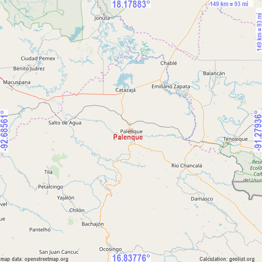
Palenque GPS coordinates[2]
17° 30' 34.308" North, 91° 58' 56.928" West
| Map corner | latitude | longitude |
|---|---|---|
| Upper-left | 18.17883°, | -92.68561° |
| Center: | 17.50953°, | -91.98248° |
| Lower-right: | 16.83776°, | -91.27936° |
| Map W x H: | 149.1×149.1 km | = 92.6×92.6mi |
| max Lat: | 32.7° ⇑83% North |
| Palenque: | 17.50953° |
| min Lat: | ⇓17% South 14.53588° |
| min Long | Palenque | max Long |
| -117.105° | -91.98248° | -86.73105° |
| W 95.3%⇐ | ⇒4.7% E |
Elevation
Elevation of Palenque is 75 m = 246 ft, and this is 1178.7 m = 3867 ft below average elevation for this country.
| Max E: |
3497 m = 11473 ft | 81.6% |
| Avg. | 1253.7 m = 4113 ft | |
| Palenque | 75 m = 246 ft | |
Min E: |
-1 m = -3 ft | 18.4% |
See also: Palenque elevation on elevation.city.
Geographical zone
Palenque is located in North Torrid zone (between Equator and Tropic of Cancer). Distance of this Northern Tropic circle is 659 km =409.5 mi to North.| Distance of | km | miles | from Palenque |
|---|---|---|---|
| North Pole | 8060.2 | 5008.4 | to North |
| Arctic Circle | 5454.3 | 3389.1 | to North |
| Tropic Cancer | 659 | 409.5 | to North |
| Equator | 1946.9 | 1209.7 | to South |


Nearby cities:
15 places around Palenque: (largest is in red/bold)
• Adolfo Ruiz Cortínes
13.7 km =8.5 mi,  180°
180°
• Babilonia
3.3 km =2.1 mi,  196°
196°
• Belisario Domínguez
11.5 km =7.1 mi, 180°
• Chivaltic Nuevo
14.5 km =9 mi,  225°
225°
• Doctor Samuel León Brindis
9.8 km =6.1 mi,  147°
147°
• El Naranjo
10.7 km =6.6 mi,  239°
239°
• Estrella de Belén
13.8 km =8.6 mi,  169°
169°
• Francisco I. Madero
17.7 km =11 mi,  205°
205°
• Ignacio Zaragoza
12.2 km =7.6 mi, 205°
• La Aurora
13.6 km =8.5 mi,  159°
159°
• Miguel Hidalgo
17.4 km =10.8 mi,  81°
81°
• Nazareth
15.7 km =9.8 mi, 166°
• Nuevo Sonora
14 km =8.7 mi,  133°
133°
• San Miguel
16.5 km =10.3 mi,  189°
189°
• Tzeltal Mukul-Já
17.3 km =10.7 mi,  312°
312°
Sources, notices
• [Note1] Compared only with cities in Mexico existing in our database
• [Src1] Map data: © OpenStreetMap contributors (CC-BY-SA)
• [Src2] Other city data from geonames.org with taken over terms of usage.
• [Src3] Geographical zone / Annual Mean Temperature by Robert A. Rohde @ Wikipedia
