Agua Fría geodata
Agua Fría (Chiapas) is a populated place; located in Mexico in America/Mexico_City (GMT-6) time zone. With population of 571 people, there are 14980 cities with bigger population in this country. Compared to other cities in Mexico, 81% of cities are located further ↑North; 94.8% of cities are located further ←West and 89.4% of cities have higher elevation than Agua Fría. Note1


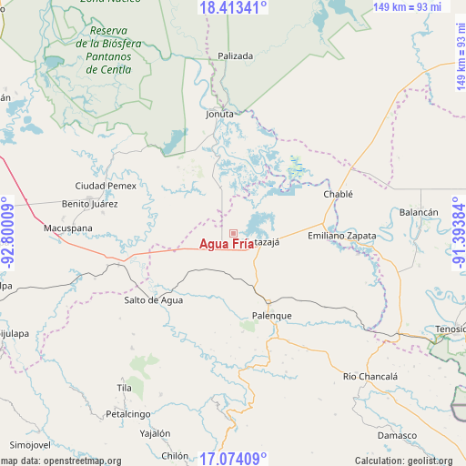
Agua Fría GPS coordinates[2]
17° 44' 42" North, 92° 5' 49.056" West
| Map corner | latitude | longitude |
|---|---|---|
| Upper-left | 18.41341°, | -92.80009° |
| Center: | 17.745°, | -92.09696° |
| Lower-right: | 17.07409°, | -91.39384° |
| Map W x H: | 148.9×148.9 km | = 92.5×92.5mi |
| max Lat: | 32.7° ⇑81% North |
| Agua Fría: | 17.745° |
| min Lat: | ⇓19% South 14.53588° |
| min Long | Agua Fría | max Long |
| -117.105° | -92.09696° | -86.73105° |
| W 94.8%⇐ | ⇒5.2% E |
Elevation
Elevation of Agua Fría is 26 m = 85 ft, and this is 1227.7 m = 4028 ft below average elevation for this country.
| Max E: |
3497 m = 11473 ft | 89.4% |
| Avg. | 1253.7 m = 4113 ft | |
| Agua Fría | 26 m = 85 ft | |
Min E: |
-1 m = -3 ft | 10.6% |
See also: Mexico elevation on elevation.city.
Geographical zone
Agua Fría is located in North Torrid zone (between Equator and Tropic of Cancer). Distance of this Northern Tropic circle is 632.9 km =393.3 mi to North.| Distance of | km | miles | from Agua Fría |
|---|---|---|---|
| North Pole | 8034 | 4992.1 | to North |
| Arctic Circle | 5428.1 | 3372.9 | to North |
| Tropic Cancer | 632.9 | 393.3 | to North |
| Equator | 1973.1 | 1226 | to South |


Nearby cities:
15 places around Agua Fría: (largest is in red/bold)
• Aquiles Serdán
20.2 km =12.6 mi,  282°
282°
• Bajadas Grandes
18.1 km =11.2 mi,  254°
254°
• Catazajá
9.3 km =5.8 mi,  104°
104°
• Cuauhtémoc
5.1 km =3.2 mi,  179°
179°
• El Paraíso
7.8 km =4.8 mi,  47°
47°
• El Rosario
6.8 km =4.2 mi,  357°
357°
• Emilio Rabasa
9.3 km =5.8 mi,  234°
234°
• Ignacio Zaragoza
12.1 km =7.5 mi,  67°
67°
• Loma Bonita
5.1 km =3.2 mi,  24°
24°
• Los Pájaros
18.3 km =11.4 mi,  6°
6°
• Punta Arena
4.1 km =2.5 mi,  88°
88°
• Ramón Grande
18.8 km =11.7 mi,  294°
294°
• Saturnino Ríos
16.7 km =10.4 mi,  217°
217°
• Tzeltal Mukul-Já
14.6 km =9.1 mi, 182°
• Venustiano Carranza
15.9 km =9.9 mi, 282°
Sources, notices
• [Note1] Compared only with cities in Mexico existing in our database
• [Src1] Map data: © OpenStreetMap contributors (CC-BY-SA)
• [Src2] Other city data from geonames.org with taken over terms of usage.
• [Src3] Geographical zone / Annual Mean Temperature by Robert A. Rohde @ Wikipedia
