Mazatecochco geodata
Mazatecochco (Tlaxcala) is a seat of a second-order administrative division; located in Mexico in America/Mexico_City (GMT-6) time zone. With population of 9,671 people, there are 988 cities with bigger population in this country. Compared to other cities in Mexico, 61.6% of cities are located further ↑North; 61.4% of cities are located further ←West and 87.4% of cities have lower elevation than Mazatecochco. Note1


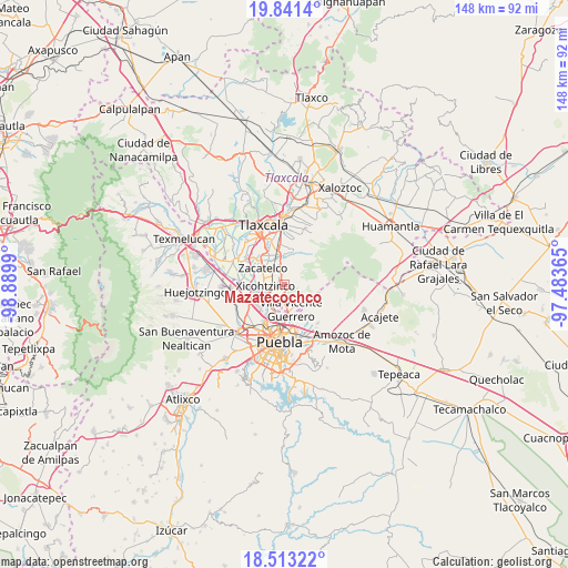
Mazatecochco GPS coordinates[2]
19° 10' 43.14" North, 98° 11' 12.372" West
| Map corner | latitude | longitude |
|---|---|---|
| Upper-left | 19.8414°, | -98.8899° |
| Center: | 19.17865°, | -98.18677° |
| Lower-right: | 18.51322°, | -97.48365° |
| Map W x H: | 147.7×147.7 km | = 91.8×91.8mi |
| max Lat: | 32.7° ⇑61.6% North |
| Mazatecochco: | 19.17865° |
| min Lat: | ⇓38.4% South 14.53588° |
| min Long | Mazatecochco | max Long |
| -117.105° | -98.18677° | -86.73105° |
| W 61.4%⇐ | ⇒38.6% E |
Elevation
Elevation of Mazatecochco is 2323 m = 7621 ft, and this is 1069.3 m = 3508 ft above average elevation for this country.
| Max E: |
3497 m = 11473 ft | 12.6% |
| Mazatecochco | 2323 m 7621 ft | |
| Avg. | 1253.7 m = 4113 ft | |
Min E: |
-1 m = -3 ft | 87.4% |
See also: Mexico elevation on elevation.city.
Geographical zone
Mazatecochco is located in North Torrid zone (between Equator and Tropic of Cancer). Distance of this Northern Tropic circle is 473.5 km =294.2 mi to North.| Distance of | km | miles | from Mazatecochco |
|---|---|---|---|
| North Pole | 7874.6 | 4893 | to North |
| Arctic Circle | 5268.7 | 3273.8 | to North |
| Tropic Cancer | 473.5 | 294.2 | to North |
| Equator | 2132.5 | 1325.1 | to South |


Nearby cities:
15 places around Mazatecochco: (largest is in red/bold)
• Acuamanala
5.2 km =3.2 mi,  343°
343°
• Almecatla
6.5 km =4 mi,  232°
232°
• Ayometitla
3.2 km =2 mi,  348°
348°
• Concepción Chimalpa
4.4 km =2.7 mi, 344°
• El Carmen Aztama
6.6 km =4.1 mi,  328°
328°
• Guadalupe Hidalgo
5.3 km =3.3 mi,  359°
359°
• Olextla de Juárez
3.9 km =2.4 mi, 354°
• Papalotla
2.1 km =1.3 mi,  238°
238°
• San Marcos Contla
2.7 km =1.7 mi, 329°
• Santa Catarina Ayometla
3.6 km =2.2 mi,  307°
307°
• Santa Cruz Quilehtla
5.5 km =3.4 mi,  317°
317°
• Tenancingo
3.8 km =2.4 mi,  203°
203°
• Villa Vicente Guerrero
6.8 km =4.2 mi,  160°
160°
• Xicohtzinco
5 km =3.1 mi,  263°
263°
• Zacatelco
6.9 km =4.3 mi, 306°
Sources, notices
• [Note1] Compared only with cities in Mexico existing in our database
• [Src1] Map data: © OpenStreetMap contributors (CC-BY-SA)
• [Src2] Other city data from geonames.org with taken over terms of usage.
• [Src3] Geographical zone / Annual Mean Temperature by Robert A. Rohde @ Wikipedia
