San Antonio Atotonilco geodata
San Antonio Atotonilco (Puebla) is a populated place; located in Mexico in America/Mexico_City (GMT-6) time zone. With population of 4,162 people, there are 2200 cities with bigger population in this country. Compared to other cities in Mexico, 56.9% of cities are located further ↑North; 57.7% of cities are located further ←West and 87.3% of cities have lower elevation than San Antonio Atotonilco. Note1
Current local time in San Antonio Atotonilco:
06:48 AM, WednesdayDifference from your time zone: hours


San Antonio Atotonilco GPS coordinates[2]
19° 22' 28.776" North, 98° 27' 57.024" West
| Map corner | latitude | longitude |
|---|---|---|
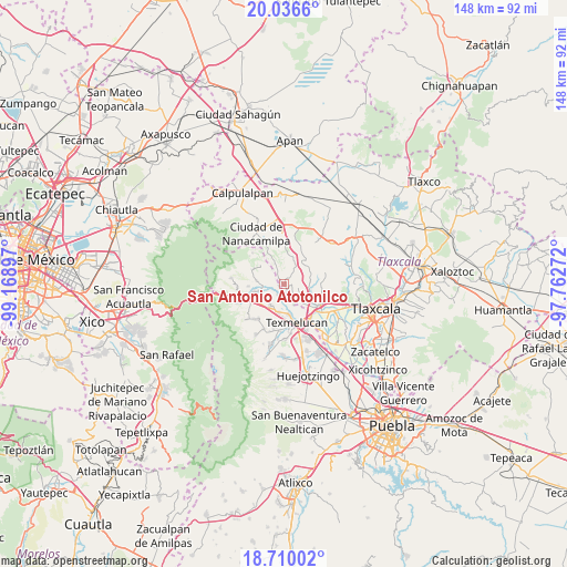
| Upper-left | 20.0366°, | -99.16897° |
| Center: | 19.37466°, | -98.46584° |
| Lower-right: | 18.71002°, | -97.76272° |
| Map W x H: | 147.5×147.5 km | = 91.7×91.7mi |
| max Lat: | 32.7° ⇑56.9% North |
| San Antonio Atotonilco: | 19.37466° |
| min Lat: | ⇓43.1% South 14.53588° |
| min Long | San Antonio Ato | max Long |
| -117.105° | -98.46584° | -86.73105° |
| W 57.7%⇐ | ⇒42.3% E |
Elevation
Elevation of San Antonio Atotonilco is 2320 m = 7612 ft, and this is 1066.3 m = 3498 ft above average elevation for this country.
| Max E: |
3497 m = 11473 ft | 12.7% |
| San Antonio Atotonilco | 2320 m 7612 ft | |
| Avg. | 1253.7 m = 4113 ft | |
Min E: |
-1 m = -3 ft | 87.3% |
See also: Mexico elevation on elevation.city.
Geographical zone
San Antonio Atotonilco is located in North Torrid zone (between Equator and Tropic of Cancer). Distance of this Northern Tropic circle is 451.7 km =280.7 mi to North.| Distance of | km | miles | from San Antonio Atotonilco |
|---|---|---|---|
| North Pole | 7852.8 | 4879.5 | to North |
| Arctic Circle | 5246.9 | 3260.3 | to North |
| Tropic Cancer | 451.7 | 280.7 | to North |
| Equator | 2154.3 | 1338.6 | to South |


Nearby cities:
15 places around San Antonio Atotonilco: (largest is in red/bold)
• Alpotzonga de Lira y Ortega
3.5 km =2.2 mi,  95°
95°
• Espíritu Santo
5.7 km =3.5 mi,  134°
134°
• Guadalupe Zaragoza
7.7 km =4.8 mi,  256°
256°
• Guadalupito las Dalias
7.8 km =4.8 mi,  306°
306°
• Juárez Coronaco
6.4 km =4 mi, 255°
• La Preciosita
9 km =5.6 mi,  294°
294°
• Palmillas
7.6 km =4.7 mi,  215°
215°
• San Francisco Mitepec
7.4 km =4.6 mi,  14°
14°
• San Francisco Tláloc
1.3 km =0.8 mi,  245°
245°
• San Lucas el Grande
7.8 km =4.8 mi,  189°
189°
• San Matias Tlalancaleca
6.5 km =4 mi,  212°
212°
• San Pedro Matamoros
9.3 km =5.8 mi,  266°
266°
• San Rafael Tlanalapan
9.2 km =5.7 mi,  181°
181°
• Santiago Coltzingo
7.3 km =4.5 mi,  277°
277°
• Vicente Guerrero
5.9 km =3.7 mi,  334°
334°
Sources, notices
• [Note1] Compared only with cities in Mexico existing in our database
• [Src1] Map data: © OpenStreetMap contributors (CC-BY-SA)
• [Src2] Other city data from geonames.org with taken over terms of usage.
• [Src3] Geographical zone / Annual Mean Temperature by Robert A. Rohde @ Wikipedia
