Espíritu Santo geodata
Espíritu Santo (Puebla) is a populated place; located in Mexico in America/Mexico_City (GMT-6) time zone. With population of 640 people, there are 13529 cities with bigger population in this country. Compared to other cities in Mexico, 57.9% of cities are located further ↑North; 58.3% of cities are located further ←West and 90.6% of cities have lower elevation than Espíritu Santo. Note1


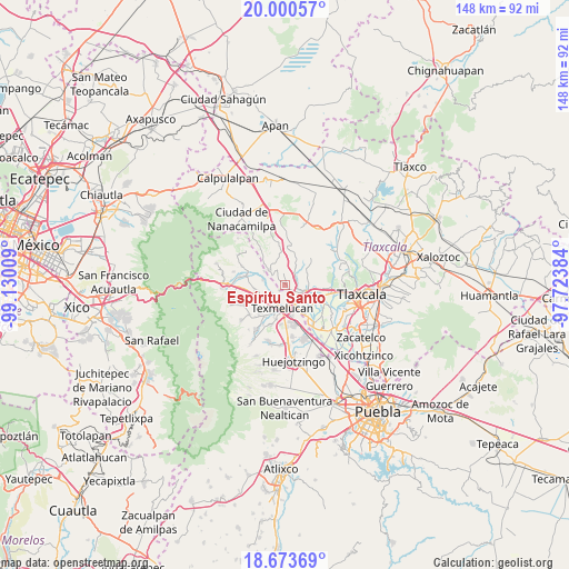
Espíritu Santo GPS coordinates[2]
19° 20' 18.528" North, 98° 25' 37.056" West
| Map corner | latitude | longitude |
|---|---|---|
| Upper-left | 20.00057°, | -99.13009° |
| Center: | 19.33848°, | -98.42696° |
| Lower-right: | 18.67369°, | -97.72384° |
| Map W x H: | 147.5×147.5 km | = 91.7×91.7mi |
| max Lat: | 32.7° ⇑57.9% North |
| Espíritu Santo: | 19.33848° |
| min Lat: | ⇓42.1% South 14.53588° |
| min Long | Espíritu Santo | max Long |
| -117.105° | -98.42696° | -86.73105° |
| W 58.3%⇐ | ⇒41.7% E |
Elevation
Elevation of Espíritu Santo is 2429 m = 7969 ft, and this is 1175.3 m = 3856 ft above average elevation for this country.
| Max E: |
3497 m = 11473 ft | 9.4% |
| Espíritu Santo | 2429 m 7969 ft | |
| Avg. | 1253.7 m = 4113 ft | |
Min E: |
-1 m = -3 ft | 90.6% |
See also: Mexico elevation on elevation.city.
Geographical zone
Espíritu Santo is located in North Torrid zone (between Equator and Tropic of Cancer). Distance of this Northern Tropic circle is 455.7 km =283.2 mi to North.| Distance of | km | miles | from Espíritu Santo |
|---|---|---|---|
| North Pole | 7856.8 | 4882 | to North |
| Arctic Circle | 5250.9 | 3262.8 | to North |
| Tropic Cancer | 455.7 | 283.2 | to North |
| Equator | 2150.2 | 1336.1 | to South |


Nearby cities:
15 places around Espíritu Santo: (largest is in red/bold)
• Alpotzonga de Lira y Ortega
3.7 km =2.3 mi,  350°
350°
• Guadalupe Victoria
7.8 km =4.8 mi,  146°
146°
• San Antonio Atotonilco
5.7 km =3.5 mi,  314°
314°
• San Francisco Tláloc
6.3 km =3.9 mi,  303°
303°
• San Lucas el Grande
6.5 km =4 mi,  236°
236°
• San Marcos Jilotepec
7 km =4.3 mi,  51°
51°
• San Martin Texmelucan de Labastida
6.2 km =3.9 mi,  191°
191°
• San Mateo Ayecac
7.4 km =4.6 mi, 152°
• San Matias Tlalancaleca
7.7 km =4.8 mi,  259°
259°
• San Rafael Tlanalapan
6.8 km =4.2 mi,  219°
219°
• Santa Cruz el Porvenir
8.3 km =5.2 mi,  95°
95°
• Santa Justina Ecatepec
8.2 km =5.1 mi,  112°
112°
• Villa Alta
5.8 km =3.6 mi, 151°
• Villa Mariano Matamoros
5.3 km =3.3 mi, 104°
• Xocoyucan
6.4 km =4 mi,  120°
120°
Sources, notices
• [Note1] Compared only with cities in Mexico existing in our database
• [Src1] Map data: © OpenStreetMap contributors (CC-BY-SA)
• [Src2] Other city data from geonames.org with taken over terms of usage.
• [Src3] Geographical zone / Annual Mean Temperature by Robert A. Rohde @ Wikipedia
