Vicente Guerrero geodata
Vicente Guerrero (Puebla) is a populated place; located in Mexico in America/Mexico_City (GMT-6) time zone. With population of 730 people, there are 11957 cities with bigger population in this country. Compared to other cities in Mexico, 55.8% of cities are located further ↑North; 57.4% of cities are located further ←West and 92.8% of cities have lower elevation than Vicente Guerrero. Note1


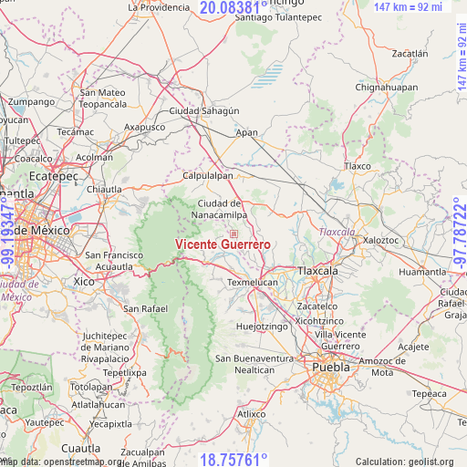
Vicente Guerrero GPS coordinates[2]
19° 25' 19.416" North, 98° 29' 25.224" West
| Map corner | latitude | longitude |
|---|---|---|
| Upper-left | 20.08381°, | -99.19347° |
| Center: | 19.42206°, | -98.49034° |
| Lower-right: | 18.75761°, | -97.78722° |
| Map W x H: | 147.5×147.5 km | = 91.7×91.7mi |
| max Lat: | 32.7° ⇑55.8% North |
| Vicente Guerrero: | 19.42206° |
| min Lat: | ⇓44.2% South 14.53588° |
| min Long | Vicente Guerrer | max Long |
| -117.105° | -98.49034° | -86.73105° |
| W 57.4%⇐ | ⇒42.6% E |
Elevation
Elevation of Vicente Guerrero is 2520 m = 8268 ft, and this is 1266.3 m = 4155 ft above average elevation for this country.
| Max E: |
3497 m = 11473 ft | 7.2% |
| Vicente Guerrero | 2520 m 8268 ft | |
| Avg. | 1253.7 m = 4113 ft | |
Min E: |
-1 m = -3 ft | 92.8% |
See also: Mexico elevation on elevation.city.
Geographical zone
Vicente Guerrero is located in North Torrid zone (between Equator and Tropic of Cancer). Distance of this Northern Tropic circle is 446.4 km =277.4 mi to North.| Distance of | km | miles | from Vicente Guerrero |
|---|---|---|---|
| North Pole | 7847.5 | 4876.2 | to North |
| Arctic Circle | 5241.6 | 3257 | to North |
| Tropic Cancer | 446.4 | 277.4 | to North |
| Equator | 2159.5 | 1341.9 | to South |


Nearby cities:
15 places around Vicente Guerrero: (largest is in red/bold)
• Alpotzonga de Lira y Ortega
8.2 km =5.1 mi,  132°
132°
• Españita
8.3 km =5.2 mi,  56°
56°
• Guadalupe Zaragoza
8.6 km =5.3 mi,  214°
214°
• Guadalupito las Dalias
3.8 km =2.4 mi,  259°
259°
• Juárez Coronaco
7.7 km =4.8 mi, 207°
• La Magdalena Cuextotitla
6.9 km =4.3 mi,  40°
40°
• La Preciosita
5.8 km =3.6 mi,  254°
254°
• San Antonio Atotonilco
5.9 km =3.7 mi,  154°
154°
• San Felipe Hidalgo
8.8 km =5.5 mi,  305°
305°
• San Francisco Mitepec
4.8 km =3 mi,  66°
66°
• San Francisco Tláloc
6 km =3.7 mi,  166°
166°
• San Pedro Matamoros
8.9 km =5.5 mi,  229°
229°
• Sanctórum
8.2 km =5.1 mi,  13°
13°
• Santa Cruz Moxolahuac
6.4 km =4 mi,  296°
296°
• Santiago Coltzingo
6.4 km =4 mi, 227°
Sources, notices
• [Note1] Compared only with cities in Mexico existing in our database
• [Src1] Map data: © OpenStreetMap contributors (CC-BY-SA)
• [Src2] Other city data from geonames.org with taken over terms of usage.
• [Src3] Geographical zone / Annual Mean Temperature by Robert A. Rohde @ Wikipedia
