Alpatláhuac geodata
Alpatláhuac (Veracruz) is a seat of a second-order administrative division; located in Mexico in America/Mexico_City (GMT-6) time zone. With population of 1,181 people, there are 7360 cities with bigger population in this country. Compared to other cities in Mexico, 62.8% of cities are located further ↑North; 73.7% of cities are located further ←West and 66.2% of cities have lower elevation than Alpatláhuac. Note1


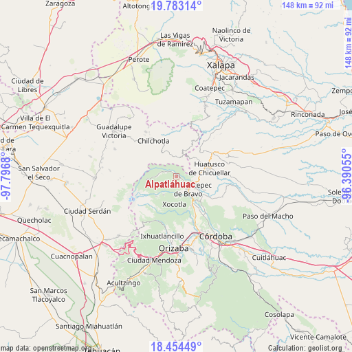
Alpatláhuac GPS coordinates[2]
19° 7' 12.54" North, 97° 5' 37.212" West
| Map corner | latitude | longitude |
|---|---|---|
| Upper-left | 19.78314°, | -97.7968° |
| Center: | 19.12015°, | -97.09367° |
| Lower-right: | 18.45449°, | -96.39055° |
| Map W x H: | 147.7×147.7 km | = 91.8×91.8mi |
| max Lat: | 32.7° ⇑62.8% North |
| Alpatláhuac: | 19.12015° |
| min Lat: | ⇓37.2% South 14.53588° |
| min Long | Alpatláhuac | max Long |
| -117.105° | -97.09367° | -86.73105° |
| W 73.7%⇐ | ⇒26.3% E |
Elevation
Elevation of Alpatláhuac is 1855 m = 6086 ft, and this is 601.3 m = 1973 ft above average elevation for this country.
| Max E: |
3497 m = 11473 ft | 33.8% |
| Alpatláhuac | 1855 m 6086 ft | |
| Avg. | 1253.7 m = 4113 ft | |
Min E: |
-1 m = -3 ft | 66.2% |
See also: Mexico elevation on elevation.city.
Geographical zone
Alpatláhuac is located in North Torrid zone (between Equator and Tropic of Cancer). Distance of this Northern Tropic circle is 480 km =298.3 mi to North.| Distance of | km | miles | from Alpatláhuac |
|---|---|---|---|
| North Pole | 7881.1 | 4897.1 | to North |
| Arctic Circle | 5275.2 | 3277.9 | to North |
| Tropic Cancer | 480 | 298.3 | to North |
| Equator | 2126 | 1321 | to South |


Nearby cities:
15 places around Alpatláhuac: (largest is in red/bold)
• Acalocotla
6.6 km =4.1 mi,  343°
343°
• Ateopa
1.4 km =0.9 mi,  247°
247°
• Ayahualulco
4.8 km =3 mi, 248°
• Calcahualco
0.9 km =0.6 mi,  73°
73°
• Cocalzingo
3.3 km =2.1 mi,  212°
212°
• Cruz Verde
2.5 km =1.6 mi,  320°
320°
• El Palmar
4.8 km =3 mi,  62°
62°
• Excola
3.7 km =2.3 mi,  304°
304°
• Nenehuaca
6 km =3.7 mi, 63°
• San José Teacalco
1.1 km =0.7 mi, 210°
• Tizapa
6.2 km =3.9 mi,  19°
19°
• Tozongo
4.1 km =2.5 mi,  122°
122°
• Tres Aguas
4.8 km =3 mi,  88°
88°
• Xilomichi
5.1 km =3.2 mi,  287°
287°
• Úrsulo Galván
6.4 km =4 mi,  127°
127°
Sources, notices
• [Note1] Compared only with cities in Mexico existing in our database
• [Src1] Map data: © OpenStreetMap contributors (CC-BY-SA)
• [Src2] Other city data from geonames.org with taken over terms of usage.
• [Src3] Geographical zone / Annual Mean Temperature by Robert A. Rohde @ Wikipedia
