Ateopa geodata
Ateopa (Veracruz) is a populated place; located in Mexico in America/Mexico_City (GMT-6) time zone. With population of 501 people, there are 16785 cities with bigger population in this country. Compared to other cities in Mexico, 62.8% of cities are located further ↑North; 73.5% of cities are located further ←West and 67.1% of cities have lower elevation than Ateopa. Note1


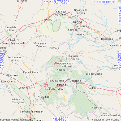
Ateopa GPS coordinates[2]
19° 6' 55.008" North, 97° 6' 21.996" West
| Map corner | latitude | longitude |
|---|---|---|
| Upper-left | 19.77829°, | -97.80924° |
| Center: | 19.11528°, | -97.10611° |
| Lower-right: | 18.4496°, | -96.40299° |
| Map W x H: | 147.7×147.7 km | = 91.8×91.8mi |
| max Lat: | 32.7° ⇑62.8% North |
| Ateopa: | 19.11528° |
| min Lat: | ⇓37.2% South 14.53588° |
| min Long | Ateopa | max Long |
| -117.105° | -97.10611° | -86.73105° |
| W 73.5%⇐ | ⇒26.5% E |
Elevation
Elevation of Ateopa is 1871 m = 6138 ft, and this is 617.3 m = 2025 ft above average elevation for this country.
| Max E: |
3497 m = 11473 ft | 32.9% |
| Ateopa | 1871 m 6138 ft | |
| Avg. | 1253.7 m = 4113 ft | |
Min E: |
-1 m = -3 ft | 67.1% |
See also: Mexico elevation on elevation.city.
Geographical zone
Ateopa is located in North Torrid zone (between Equator and Tropic of Cancer). Distance of this Northern Tropic circle is 480.5 km =298.6 mi to North.| Distance of | km | miles | from Ateopa |
|---|---|---|---|
| North Pole | 7881.6 | 4897.4 | to North |
| Arctic Circle | 5275.8 | 3278.2 | to North |
| Tropic Cancer | 480.5 | 298.6 | to North |
| Equator | 2125.4 | 1320.7 | to South |


Nearby cities:
15 places around Ateopa: (largest is in red/bold)
• Acalocotla
6.9 km =4.3 mi,  355°
355°
• Alpatláhuac
1.4 km =0.9 mi,  67°
67°
• Ayahualulco
3.3 km =2.1 mi,  248°
248°
• Calcahualco
2.3 km =1.4 mi, 69°
• Cocalzingo
2.3 km =1.4 mi,  191°
191°
• Cruz Verde
2.5 km =1.6 mi,  353°
353°
• El Palmar
6.2 km =3.9 mi,  64°
64°
• Excola
3.1 km =1.9 mi,  326°
326°
• Ixtayuca (San Nicolás)
6.7 km =4.2 mi,  153°
153°
• San José Teacalco
0.8 km =0.5 mi,  116°
116°
• Tizapa
7.2 km =4.5 mi,  27°
27°
• Totozinapa
6.4 km =4 mi,  280°
280°
• Tozongo
5 km =3.1 mi,  109°
109°
• Tres Aguas
6.1 km =3.8 mi,  83°
83°
• Xilomichi
4.1 km =2.5 mi,  300°
300°
Sources, notices
• [Note1] Compared only with cities in Mexico existing in our database
• [Src1] Map data: © OpenStreetMap contributors (CC-BY-SA)
• [Src2] Other city data from geonames.org with taken over terms of usage.
• [Src3] Geographical zone / Annual Mean Temperature by Robert A. Rohde @ Wikipedia
