El Palmar geodata
El Palmar (Puebla) is a populated place; located in Mexico in America/Mexico_City (GMT-6) time zone. With population of 1,560 people, there are 5531 cities with bigger population in this country. Compared to other cities in Mexico, 62.4% of cities are located further ↑North; 74.2% of cities are located further ←West and 65.9% of cities have lower elevation than El Palmar. Note1


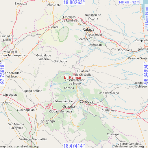
El Palmar GPS coordinates[2]
19° 8' 22.992" North, 97° 3' 11.016" West
| Map corner | latitude | longitude |
|---|---|---|
| Upper-left | 19.80263°, | -97.75619° |
| Center: | 19.13972°, | -97.05306° |
| Lower-right: | 18.47414°, | -96.34994° |
| Map W x H: | 147.7×147.7 km | = 91.8×91.8mi |
| max Lat: | 32.7° ⇑62.4% North |
| El Palmar: | 19.13972° |
| min Lat: | ⇓37.6% South 14.53588° |
| min Long | El Palmar | max Long |
| -117.105° | -97.05306° | -86.73105° |
| W 74.2%⇐ | ⇒25.8% E |
Elevation
Elevation of El Palmar is 1848 m = 6063 ft, and this is 594.3 m = 1950 ft above average elevation for this country.
| Max E: |
3497 m = 11473 ft | 34.1% |
| El Palmar | 1848 m 6063 ft | |
| Avg. | 1253.7 m = 4113 ft | |
Min E: |
-1 m = -3 ft | 65.9% |
See also: Mexico elevation on elevation.city.
Geographical zone
El Palmar is located in North Torrid zone (between Equator and Tropic of Cancer). Distance of this Northern Tropic circle is 477.8 km =296.9 mi to North.| Distance of | km | miles | from El Palmar |
|---|---|---|---|
| North Pole | 7878.9 | 4895.7 | to North |
| Arctic Circle | 5273 | 3276.5 | to North |
| Tropic Cancer | 477.8 | 296.9 | to North |
| Equator | 2128.1 | 1322.3 | to South |


Nearby cities:
15 places around El Palmar: (largest is in red/bold)
• Adolfo Ruiz Cortines (La Pastoría)
5.6 km =3.5 mi,  83°
83°
• Alpatláhuac
4.8 km =3 mi,  242°
242°
• Calcahualco
3.9 km =2.4 mi, 240°
• Chalchitepec
2.8 km =1.7 mi,  46°
46°
• Cruz Verde
5.8 km =3.6 mi,  267°
267°
• Dos Ríos
5.5 km =3.4 mi,  334°
334°
• El Progreso
2.8 km =1.7 mi,  8°
8°
• Elotepec
5.6 km =3.5 mi,  16°
16°
• Nenehuaca
1.2 km =0.7 mi,  67°
67°
• Rancho Nuevo
4.4 km =2.7 mi,  358°
358°
• San José Teacalco
5.7 km =3.5 mi, 237°
• Tepampa
3.2 km =2 mi,  85°
85°
• Tizapa
4.3 km =2.7 mi, 328°
• Tozongo
4.5 km =2.8 mi,  190°
190°
• Tres Aguas
2.1 km =1.3 mi,  165°
165°
Sources, notices
• [Note1] Compared only with cities in Mexico existing in our database
• [Src1] Map data: © OpenStreetMap contributors (CC-BY-SA)
• [Src2] Other city data from geonames.org with taken over terms of usage.
• [Src3] Geographical zone / Annual Mean Temperature by Robert A. Rohde @ Wikipedia
