Cruz Verde geodata
Cruz Verde (Veracruz) is a populated place; located in Mexico in America/Mexico_City (GMT-6) time zone. With population of 1,005 people, there are 8675 cities with bigger population in this country. Compared to other cities in Mexico, 62.4% of cities are located further ↑North; 73.5% of cities are located further ←West and 70.9% of cities have lower elevation than Cruz Verde. Note1


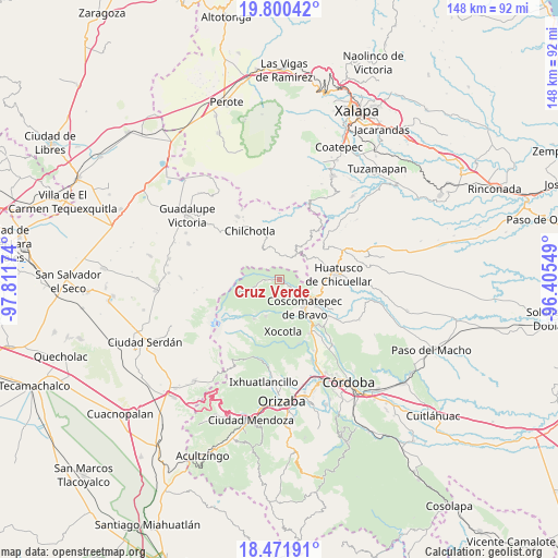
Cruz Verde GPS coordinates[2]
19° 8' 15" North, 97° 6' 30.996" West
| Map corner | latitude | longitude |
|---|---|---|
| Upper-left | 19.80042°, | -97.81174° |
| Center: | 19.1375°, | -97.10861° |
| Lower-right: | 18.47191°, | -96.40549° |
| Map W x H: | 147.7×147.7 km | = 91.8×91.8mi |
| max Lat: | 32.7° ⇑62.4% North |
| Cruz Verde: | 19.1375° |
| min Lat: | ⇓37.6% South 14.53588° |
| min Long | Cruz Verde | max Long |
| -117.105° | -97.10861° | -86.73105° |
| W 73.5%⇐ | ⇒26.5% E |
Elevation
Elevation of Cruz Verde is 1943 m = 6375 ft, and this is 689.3 m = 2261 ft above average elevation for this country.
| Max E: |
3497 m = 11473 ft | 29.1% |
| Cruz Verde | 1943 m 6375 ft | |
| Avg. | 1253.7 m = 4113 ft | |
Min E: |
-1 m = -3 ft | 70.9% |
See also: Mexico elevation on elevation.city.
Geographical zone
Cruz Verde is located in North Torrid zone (between Equator and Tropic of Cancer). Distance of this Northern Tropic circle is 478 km =297 mi to North.| Distance of | km | miles | from Cruz Verde |
|---|---|---|---|
| North Pole | 7879.2 | 4895.9 | to North |
| Arctic Circle | 5273.3 | 3276.7 | to North |
| Tropic Cancer | 478 | 297 | to North |
| Equator | 2127.9 | 1322.2 | to South |


Nearby cities:
15 places around Cruz Verde: (largest is in red/bold)
• Acalocotla
4.4 km =2.7 mi,  356°
356°
• Alpatláhuac
2.5 km =1.6 mi,  140°
140°
• Ateopa
2.5 km =1.6 mi,  173°
173°
• Atlaxco
5.9 km =3.7 mi,  19°
19°
• Ayahualulco
4.7 km =2.9 mi,  217°
217°
• Calcahualco
2.9 km =1.8 mi,  124°
124°
• Cocalzingo
4.7 km =2.9 mi,  182°
182°
• Dos Ríos
6.2 km =3.9 mi,  33°
33°
• El Palmar
5.8 km =3.6 mi,  87°
87°
• Excola
1.5 km =0.9 mi,  275°
275°
• San José Acatla
6 km =3.7 mi,  348°
348°
• San José Teacalco
3 km =1.9 mi,  160°
160°
• Tizapa
5.3 km =3.3 mi,  42°
42°
• Totozinapa
6.2 km =3.9 mi,  257°
257°
• Xilomichi
3.3 km =2.1 mi, 263°
Sources, notices
• [Note1] Compared only with cities in Mexico existing in our database
• [Src1] Map data: © OpenStreetMap contributors (CC-BY-SA)
• [Src2] Other city data from geonames.org with taken over terms of usage.
• [Src3] Geographical zone / Annual Mean Temperature by Robert A. Rohde @ Wikipedia
