Úrsulo Galván geodata
Úrsulo Galván (Veracruz) is a populated place; located in Mexico in America/Mexico_City (GMT-6) time zone. With population of 586 people, there are 14641 cities with bigger population in this country. Compared to other cities in Mexico, 63.3% of cities are located further ↑North; 74.3% of cities are located further ←West and 51.5% of cities have lower elevation than Úrsulo Galván. Note1


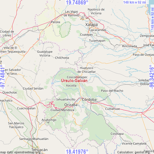
Úrsulo Galván GPS coordinates[2]
19° 5' 8.016" North, 97° 2' 43.008" West
| Map corner | latitude | longitude |
|---|---|---|
| Upper-left | 19.74869°, | -97.74841° |
| Center: | 19.08556°, | -97.04528° |
| Lower-right: | 18.41976°, | -96.34216° |
| Map W x H: | 147.8×147.8 km | = 91.8×91.8mi |
| max Lat: | 32.7° ⇑63.3% North |
| Úrsulo Galván: | 19.08556° |
| min Lat: | ⇓36.7% South 14.53588° |
| min Long | Úrsulo Galván | max Long |
| -117.105° | -97.04528° | -86.73105° |
| W 74.3%⇐ | ⇒25.7% E |
Elevation
Elevation of Úrsulo Galván is 1505 m = 4938 ft, and this is 251.3 m = 824 ft above average elevation for this country.
| Max E: |
3497 m = 11473 ft | 48.5% |
| Úrsulo Galván | 1505 m 4938 ft | |
| Avg. | 1253.7 m = 4113 ft | |
Min E: |
-1 m = -3 ft | 51.5% |
See also: Mexico elevation on elevation.city.
Geographical zone
Úrsulo Galván is located in North Torrid zone (between Equator and Tropic of Cancer). Distance of this Northern Tropic circle is 483.8 km =300.6 mi to North.| Distance of | km | miles | from Úrsulo Galván |
|---|---|---|---|
| North Pole | 7884.9 | 4899.4 | to North |
| Arctic Circle | 5279.1 | 3280.3 | to North |
| Tropic Cancer | 483.8 | 300.6 | to North |
| Equator | 2122.1 | 1318.6 | to South |


Nearby cities:
15 places around Úrsulo Galván: (largest is in red/bold)
• Alpatláhuac
6.4 km =4 mi,  307°
307°
• Calaquioco
6.2 km =3.9 mi,  169°
169°
• Calcahualco
5.9 km =3.7 mi, 314°
• Coscomatepec de Bravo
1.4 km =0.9 mi,  186°
186°
• El Palmar
6.1 km =3.8 mi,  352°
352°
• Gonzalo Vázquez Vela
3.3 km =2.1 mi, 192°
• Ixtayuca (San Nicolás)
4.3 km =2.7 mi,  231°
231°
• Lázaro Cárdenas
1.7 km =1.1 mi,  100°
100°
• Nicanor Espejo
2.6 km =1.6 mi, 185°
• San José Teacalco
6.4 km =4 mi,  297°
297°
• Tetlaxco
5.4 km =3.4 mi,  201°
201°
• Tlaltengo
4.3 km =2.7 mi, 95°
• Tozongo
2.3 km =1.4 mi,  315°
315°
• Tres Aguas
4 km =2.5 mi,  355°
355°
• Xalatlaco
4 km =2.5 mi, 173°
Sources, notices
• [Note1] Compared only with cities in Mexico existing in our database
• [Src1] Map data: © OpenStreetMap contributors (CC-BY-SA)
• [Src2] Other city data from geonames.org with taken over terms of usage.
• [Src3] Geographical zone / Annual Mean Temperature by Robert A. Rohde @ Wikipedia
