El Aguacate geodata
El Aguacate (Veracruz) is a populated place; located in Mexico in America/Mexico_City (GMT-6) time zone. With population of 2,030 people, there are 4290 cities with bigger population in this country. Compared to other cities in Mexico, 76.2% of cities are located further ↑North; 84.7% of cities are located further ←West and 69.4% of cities have higher elevation than El Aguacate. Note1


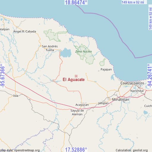
El Aguacate GPS coordinates[2]
18° 11' 53.088" North, 94° 58' 13.908" West
| Map corner | latitude | longitude |
|---|---|---|
| Upper-left | 18.86474°, | -95.67366° |
| Center: | 18.19808°, | -94.97053° |
| Lower-right: | 17.52886°, | -94.26741° |
| Map W x H: | 148.5×148.5 km | = 92.3×92.3mi |
| max Lat: | 32.7° ⇑76.2% North |
| El Aguacate: | 18.19808° |
| min Lat: | ⇓23.8% South 14.53588° |
| min Long | El Aguacate | max Long |
| -117.105° | -94.97053° | -86.73105° |
| W 84.7%⇐ | ⇒15.3% E |
Elevation
Elevation of El Aguacate is 450 m = 1476 ft, and this is 803.7 m = 2637 ft below average elevation for this country.
| Max E: |
3497 m = 11473 ft | 69.4% |
| Avg. | 1253.7 m = 4113 ft | |
| El Aguacate | 450 m = 1476 ft | |
Min E: |
-1 m = -3 ft | 30.6% |
See also: Mexico elevation on elevation.city.
Geographical zone
El Aguacate is located in North Torrid zone (between Equator and Tropic of Cancer). Distance of this Northern Tropic circle is 582.5 km =361.9 mi to North.| Distance of | km | miles | from El Aguacate |
|---|---|---|---|
| North Pole | 7983.6 | 4960.8 | to North |
| Arctic Circle | 5377.7 | 3341.5 | to North |
| Tropic Cancer | 582.5 | 361.9 | to North |
| Equator | 2023.4 | 1257.3 | to South |


Nearby cities:
15 places around El Aguacate: (largest is in red/bold)
• Buenavista
5.2 km =3.2 mi,  50°
50°
• Colonia Hermosa
11.6 km =7.2 mi,  225°
225°
• Cuilonia Nuevo
7.6 km =4.7 mi,  129°
129°
• El Tulín
5.8 km =3.6 mi,  17°
17°
• General Hilario C. Salas
8.6 km =5.3 mi,  344°
344°
• Las Palomas (Bajo Paloma)
9.3 km =5.8 mi, 127°
• Loma de Sogotegoyo
2.3 km =1.4 mi,  351°
351°
• Loma de la Palma
5.5 km =3.4 mi, 340°
• Morelos
3 km =1.9 mi, 132°
• Nacaxtle
10.3 km =6.4 mi,  242°
242°
• Ocozotepec
9.3 km =5.8 mi,  43°
43°
• Sabaneta
12 km =7.5 mi,  283°
283°
• San Fernando
12 km =7.5 mi, 48°
• Soteapan
11 km =6.8 mi,  68°
68°
• Tierra Nueva
5.6 km =3.5 mi, 281°
Sources, notices
• [Note1] Compared only with cities in Mexico existing in our database
• [Src1] Map data: © OpenStreetMap contributors (CC-BY-SA)
• [Src2] Other city data from geonames.org with taken over terms of usage.
• [Src3] Geographical zone / Annual Mean Temperature by Robert A. Rohde @ Wikipedia
