Loma de la Palma geodata
Loma de la Palma (Veracruz) is a populated place; located in Mexico in America/Mexico_City (GMT-6) time zone. With population of 583 people, there are 14713 cities with bigger population in this country. Compared to other cities in Mexico, 75.6% of cities are located further ↑North; 84.7% of cities are located further ←West and 67.4% of cities have higher elevation than Loma de la Palma. Note1


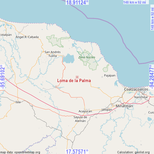
Loma de la Palma GPS coordinates[2]
18° 14' 41.136" North, 94° 59' 16.404" West
| Map corner | latitude | longitude |
|---|---|---|
| Upper-left | 18.91124°, | -95.69102° |
| Center: | 18.24476°, | -94.98789° |
| Lower-right: | 17.57571°, | -94.28477° |
| Map W x H: | 148.5×148.5 km | = 92.3×92.3mi |
| max Lat: | 32.7° ⇑75.6% North |
| Loma de la Palma: | 18.24476° |
| min Lat: | ⇓24.4% South 14.53588° |
| min Long | Loma de la Palm | max Long |
| -117.105° | -94.98789° | -86.73105° |
| W 84.7%⇐ | ⇒15.3% E |
Elevation
Elevation of Loma de la Palma is 557 m = 1827 ft, and this is 696.7 m = 2286 ft below average elevation for this country.
| Max E: |
3497 m = 11473 ft | 67.4% |
| Avg. | 1253.7 m = 4113 ft | |
| Loma de la Palma | 557 m = 1827 ft | |
Min E: |
-1 m = -3 ft | 32.6% |
See also: Mexico elevation on elevation.city.
Geographical zone
Loma de la Palma is located in North Torrid zone (between Equator and Tropic of Cancer). Distance of this Northern Tropic circle is 577.3 km =358.7 mi to North.| Distance of | km | miles | from Loma de la Palma |
|---|---|---|---|
| North Pole | 7978.4 | 4957.5 | to North |
| Arctic Circle | 5372.5 | 3338.3 | to North |
| Tropic Cancer | 577.3 | 358.7 | to North |
| Equator | 2028.6 | 1260.5 | to South |


Nearby cities:
15 places around Loma de la Palma: (largest is in red/bold)
• Buenavista
6.1 km =3.8 mi,  107°
107°
• Colonia la Magdalena
9.7 km =6 mi,  357°
357°
• Cuilonia Nuevo
12.7 km =7.9 mi,  142°
142°
• El Aguacate
5.5 km =3.4 mi,  160°
160°
• El Tulín
3.6 km =2.2 mi,  85°
85°
• General Hilario C. Salas
3.1 km =1.9 mi,  351°
351°
• Loma de Sogotegoyo
3.2 km =2 mi,  152°
152°
• Morelos
8.3 km =5.2 mi, 150°
• Nacaxtle
12.3 km =7.6 mi,  216°
216°
• Ocozotepec
8.3 km =5.2 mi,  79°
79°
• Sabaneta
10.1 km =6.3 mi,  256°
256°
• San Fernando
11.2 km =7 mi, 76°
• Santa Rosa Loma Larga
10.6 km =6.6 mi, 261°
• Soteapan
12.2 km =7.6 mi,  95°
95°
• Tierra Nueva
5.4 km =3.4 mi, 221°
Sources, notices
• [Note1] Compared only with cities in Mexico existing in our database
• [Src1] Map data: © OpenStreetMap contributors (CC-BY-SA)
• [Src2] Other city data from geonames.org with taken over terms of usage.
• [Src3] Geographical zone / Annual Mean Temperature by Robert A. Rohde @ Wikipedia
