Pachuca geodata
Pachuca (Veracruz) is a populated place; located in Mexico in America/Mexico_City (GMT-6) time zone. With population of 671 people, there are 12936 cities with bigger population in this country. Compared to other cities in Mexico, 73.6% of cities are located further ↑North; 82.6% of cities are located further ←West and 95.7% of cities have higher elevation than Pachuca. Note1


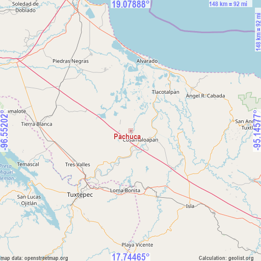
Pachuca GPS coordinates[2]
18° 24' 47.016" North, 95° 50' 56.004" West
| Map corner | latitude | longitude |
|---|---|---|
| Upper-left | 19.07888°, | -96.55202° |
| Center: | 18.41306°, | -95.84889° |
| Lower-right: | 17.74465°, | -95.14577° |
| Map W x H: | 148.4×148.4 km | = 92.2×92.2mi |
| max Lat: | 32.7° ⇑73.6% North |
| Pachuca: | 18.41306° |
| min Lat: | ⇓26.4% South 14.53588° |
| min Long | Pachuca | max Long |
| -117.105° | -95.84889° | -86.73105° |
| W 82.6%⇐ | ⇒17.4% E |
Elevation
Elevation of Pachuca is 12 m = 39 ft, and this is 1241.7 m = 4074 ft below average elevation for this country.
| Max E: |
3497 m = 11473 ft | 95.7% |
| Avg. | 1253.7 m = 4113 ft | |
| Pachuca | 12 m = 39 ft | |
Min E: |
-1 m = -3 ft | 4.3% |
See also: Mexico elevation on elevation.city.
Geographical zone
Pachuca is located in North Torrid zone (between Equator and Tropic of Cancer). Distance of this Northern Tropic circle is 558.6 km =347.1 mi to North.| Distance of | km | miles | from Pachuca |
|---|---|---|---|
| North Pole | 7959.7 | 4945.9 | to North |
| Arctic Circle | 5353.8 | 3326.7 | to North |
| Tropic Cancer | 558.6 | 347.1 | to North |
| Equator | 2047.3 | 1272.1 | to South |


Nearby cities:
15 places around Pachuca: (largest is in red/bold)
• Acula
13 km =8.1 mi,  37°
37°
• Amatitlán
12.4 km =7.7 mi,  80°
80°
• Arroyo del Soldado (Arroyo del Obispo)
13.1 km =8.1 mi,  145°
145°
• Carlos A. Carrillo
10.8 km =6.7 mi,  113°
113°
• Cerro Colorado
13.7 km =8.5 mi,  180°
180°
• Chacaltianguis
12 km =7.5 mi, 176°
• Chicalpextle
3.2 km =2 mi,  144°
144°
• Cosamaloapan
7.3 km =4.5 mi,  133°
133°
• El Corte
12.8 km =8 mi,  70°
70°
• El Mirador
6.9 km =4.3 mi,  225°
225°
• Fernando López Arias
12 km =7.5 mi, 232°
• Los Bálsamos
9.6 km =6 mi,  218°
218°
• Mozapa
1.3 km =0.8 mi, 175°
• San Francisco (Oyozontle)
9.3 km =5.8 mi, 178°
• Santiago
4.4 km =2.7 mi,  26°
26°
Sources, notices
• [Note1] Compared only with cities in Mexico existing in our database
• [Src1] Map data: © OpenStreetMap contributors (CC-BY-SA)
• [Src2] Other city data from geonames.org with taken over terms of usage.
• [Src3] Geographical zone / Annual Mean Temperature by Robert A. Rohde @ Wikipedia
