Achiquihuixtla geodata
Achiquihuixtla (Hidalgo) is a populated place; located in Mexico in America/Mexico_City (GMT-6) time zone. With population of 910 people, there are 9586 cities with bigger population in this country. Compared to other cities in Mexico, 76.2% of cities are located further ↓South; 59% of cities are located further ←West and 71.4% of cities have higher elevation than Achiquihuixtla. Note1


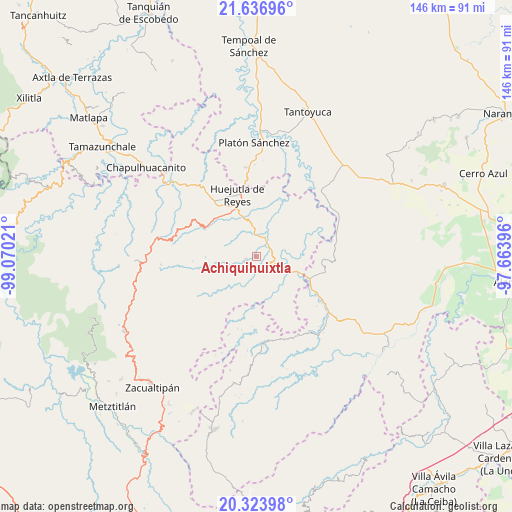
Achiquihuixtla GPS coordinates[2]
20° 58' 54.876" North, 98° 22' 1.488" West
| Map corner | latitude | longitude |
|---|---|---|
| Upper-left | 21.63696°, | -99.07021° |
| Center: | 20.98191°, | -98.36708° |
| Lower-right: | 20.32398°, | -97.66396° |
| Map W x H: | 146×146 km | = 90.7×90.7mi |
| max Lat: | 32.7° ⇑23.8% North |
| Achiquihuixtla: | 20.98191° |
| min Lat: | ⇓76.2% South 14.53588° |
| min Long | Achiquihuixtla | max Long |
| -117.105° | -98.36708° | -86.73105° |
| W 59%⇐ | ⇒41% E |
Elevation
Elevation of Achiquihuixtla is 354 m = 1161 ft, and this is 899.7 m = 2952 ft below average elevation for this country.
| Max E: |
3497 m = 11473 ft | 71.4% |
| Avg. | 1253.7 m = 4113 ft | |
| Achiquihuixtla | 354 m = 1161 ft | |
Min E: |
-1 m = -3 ft | 28.6% |
See also: Mexico elevation on elevation.city.
Geographical zone
Achiquihuixtla is located in North Torrid zone (between Equator and Tropic of Cancer). Distance of this Northern Tropic circle is 272.9 km =169.6 mi to North.| Distance of | km | miles | from Achiquihuixtla |
|---|---|---|---|
| North Pole | 7674.1 | 4768.5 | to North |
| Arctic Circle | 5068.2 | 3149.2 | to North |
| Tropic Cancer | 272.9 | 169.6 | to North |
| Equator | 2333 | 1449.7 | to South |


Nearby cities:
15 places around Achiquihuixtla: (largest is in red/bold)
• Atlapexco
4.7 km =2.9 mi,  25°
25°
• Coatzonco
6.8 km =4.2 mi,  82°
82°
• Huitzotlaco
6.6 km =4.1 mi,  350°
350°
• Los Puentes
8.6 km =5.3 mi,  41°
41°
• Mecatlán
6.3 km =3.9 mi,  216°
216°
• Oxeloco
8.2 km =5.1 mi,  148°
148°
• Pahactla
1.4 km =0.9 mi,  126°
126°
• Pepeyocatitla
8.1 km =5 mi,  202°
202°
• San Isidro
7.8 km =4.8 mi,  301°
301°
• Tecacahuaco
5.4 km =3.4 mi, 147°
• Tecolotitla
2.6 km =1.6 mi,  7°
7°
• Tepetitla
2.9 km =1.8 mi, 217°
• Tetla
6.8 km =4.2 mi,  173°
173°
• Tlalchiyahualica
3.6 km =2.2 mi,  250°
250°
• Yahualica
3.4 km =2.1 mi, 204°
Sources, notices
• [Note1] Compared only with cities in Mexico existing in our database
• [Src1] Map data: © OpenStreetMap contributors (CC-BY-SA)
• [Src2] Other city data from geonames.org with taken over terms of usage.
• [Src3] Geographical zone / Annual Mean Temperature by Robert A. Rohde @ Wikipedia
