Mecatlán geodata
Mecatlán (Hidalgo) is a populated place; located in Mexico in America/Mexico_City (GMT-6) time zone. With population of 1,803 people, there are 4827 cities with bigger population in this country. Compared to other cities in Mexico, 75.4% of cities are located further ↓South; 58.6% of cities are located further ←West and 69.3% of cities have higher elevation than Mecatlán. Note1


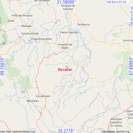
Mecatlán GPS coordinates[2]
20° 56' 8.628" North, 98° 24' 10.98" West
| Map corner | latitude | longitude |
|---|---|---|
| Upper-left | 21.59098°, | -99.10618° |
| Center: | 20.93573°, | -98.40305° |
| Lower-right: | 20.2776°, | -97.69993° |
| Map W x H: | 146×146 km | = 90.7×90.7mi |
| max Lat: | 32.7° ⇑24.6% North |
| Mecatlán: | 20.93573° |
| min Lat: | ⇓75.4% South 14.53588° |
| min Long | Mecatlán | max Long |
| -117.105° | -98.40305° | -86.73105° |
| W 58.6%⇐ | ⇒41.4% E |
Elevation
Elevation of Mecatlán is 453 m = 1486 ft, and this is 800.7 m = 2627 ft below average elevation for this country.
| Max E: |
3497 m = 11473 ft | 69.3% |
| Avg. | 1253.7 m = 4113 ft | |
| Mecatlán | 453 m = 1486 ft | |
Min E: |
-1 m = -3 ft | 30.7% |
See also: Mexico elevation on elevation.city.
Geographical zone
Mecatlán is located in North Torrid zone (between Equator and Tropic of Cancer). Distance of this Northern Tropic circle is 278.1 km =172.8 mi to North.| Distance of | km | miles | from Mecatlán |
|---|---|---|---|
| North Pole | 7679.2 | 4771.6 | to North |
| Arctic Circle | 5073.3 | 3152.4 | to North |
| Tropic Cancer | 278.1 | 172.8 | to North |
| Equator | 2327.8 | 1446.4 | to South |


Nearby cities:
15 places around Mecatlán: (largest is in red/bold)
• Achiquihuixtla
6.3 km =3.9 mi,  36°
36°
• Pahactla
6.5 km =4 mi,  48°
48°
• Papatlatla
6.3 km =3.9 mi,  233°
233°
• Pepeyocatitla
2.5 km =1.6 mi,  165°
165°
• Santa Lucía (Mesa de Santa Lucía)
3.3 km =2.1 mi,  270°
270°
• Santa Teresa
5.5 km =3.4 mi,  158°
158°
• Santo Tomás
7.7 km =4.8 mi,  318°
318°
• Tecacahuaco
6.7 km =4.2 mi,  84°
84°
• Tenamaxtepec
7.2 km =4.5 mi,  143°
143°
• Tepetitla
3.5 km =2.2 mi,  34°
34°
• Tetla
4.9 km =3 mi,  110°
110°
• Tlalchiyahualica
3.9 km =2.4 mi,  5°
5°
• Xoxolpa
7 km =4.3 mi,  197°
197°
• Yahualica
3.1 km =1.9 mi, 49°
• Zoquitipán
4.3 km =2.7 mi, 225°
Sources, notices
• [Note1] Compared only with cities in Mexico existing in our database
• [Src1] Map data: © OpenStreetMap contributors (CC-BY-SA)
• [Src2] Other city data from geonames.org with taken over terms of usage.
• [Src3] Geographical zone / Annual Mean Temperature by Robert A. Rohde @ Wikipedia
