Coatzonco geodata
Coatzonco (Hidalgo) is a populated place; located in Mexico in America/Mexico_City (GMT-6) time zone. With population of 543 people, there are 15651 cities with bigger population in this country. Compared to other cities in Mexico, 76.3% of cities are located further ↓South; 59.8% of cities are located further ←West and 75.8% of cities have higher elevation than Coatzonco. Note1


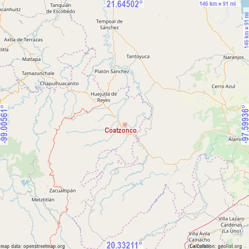
Coatzonco GPS coordinates[2]
20° 59' 24.036" North, 98° 18' 8.928" West
| Map corner | latitude | longitude |
|---|---|---|
| Upper-left | 21.64502°, | -99.00561° |
| Center: | 20.99001°, | -98.30248° |
| Lower-right: | 20.33211°, | -97.59936° |
| Map W x H: | 146×146 km | = 90.7×90.7mi |
| max Lat: | 32.7° ⇑23.7% North |
| Coatzonco: | 20.99001° |
| min Lat: | ⇓76.3% South 14.53588° |
| min Long | Coatzonco | max Long |
| -117.105° | -98.30248° | -86.73105° |
| W 59.8%⇐ | ⇒40.2% E |
Elevation
Elevation of Coatzonco is 195 m = 640 ft, and this is 1058.7 m = 3473 ft below average elevation for this country.
| Max E: |
3497 m = 11473 ft | 75.8% |
| Avg. | 1253.7 m = 4113 ft | |
| Coatzonco | 195 m = 640 ft | |
Min E: |
-1 m = -3 ft | 24.2% |
See also: Mexico elevation on elevation.city.
Geographical zone
Coatzonco is located in North Torrid zone (between Equator and Tropic of Cancer). Distance of this Northern Tropic circle is 272 km =169 mi to North.| Distance of | km | miles | from Coatzonco |
|---|---|---|---|
| North Pole | 7673.2 | 4767.9 | to North |
| Arctic Circle | 5067.3 | 3148.7 | to North |
| Tropic Cancer | 272 | 169 | to North |
| Equator | 2333.9 | 1450.2 | to South |


Nearby cities:
15 places around Coatzonco: (largest is in red/bold)
• Acatepec
5 km =3.1 mi,  143°
143°
• Acatipa
9 km =5.6 mi,  153°
153°
• Achiquihuixtla
6.8 km =4.2 mi,  262°
262°
• Ahuehuetl
6.7 km =4.2 mi,  16°
16°
• Atlapexco
5.7 km =3.5 mi,  305°
305°
• Huautla
4.8 km =3 mi, 19°
• Huazalinguillo
5.7 km =3.5 mi,  87°
87°
• Los Puentes
5.7 km =3.5 mi,  350°
350°
• Oxeloco
8.3 km =5.2 mi,  196°
196°
• Pahactla
5.9 km =3.7 mi,  252°
252°
• Tamoyón I
6.9 km =4.3 mi,  56°
56°
• Tecacahuaco
6.6 km =4.1 mi,  214°
214°
• Tecolotitla
6.6 km =4.1 mi,  285°
285°
• Tlacuapan
6.1 km =3.8 mi, 354°
• Yahualica
9 km =5.6 mi,  243°
243°
Sources, notices
• [Note1] Compared only with cities in Mexico existing in our database
• [Src1] Map data: © OpenStreetMap contributors (CC-BY-SA)
• [Src2] Other city data from geonames.org with taken over terms of usage.
• [Src3] Geographical zone / Annual Mean Temperature by Robert A. Rohde @ Wikipedia
