Lagunillas geodata
Lagunillas (Oaxaca) is a populated place; located in Mexico in America/Mexico_City (GMT-6) time zone. With population of 522 people, there are 16162 cities with bigger population in this country. Compared to other cities in Mexico, 95.3% of cities are located further ↑North; 60.9% of cities are located further ←West and 83.9% of cities have higher elevation than Lagunillas. Note1


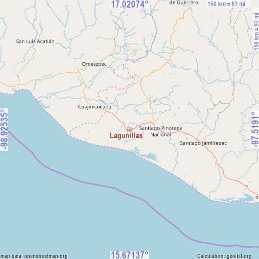
Lagunillas GPS coordinates[2]
16° 20' 49.992" North, 98° 13' 19.992" West
| Map corner | latitude | longitude |
|---|---|---|
| Upper-left | 17.02074°, | -98.92535° |
| Center: | 16.34722°, | -98.22222° |
| Lower-right: | 15.67137°, | -97.5191° |
| Map W x H: | 150×150 km | = 93.2×93.2mi |
| max Lat: | 32.7° ⇑95.3% North |
| Lagunillas: | 16.34722° |
| min Lat: | ⇓4.7% South 14.53588° |
| min Long | Lagunillas | max Long |
| -117.105° | -98.22222° | -86.73105° |
| W 60.9%⇐ | ⇒39.1% E |
Elevation
Elevation of Lagunillas is 52 m = 171 ft, and this is 1201.7 m = 3943 ft below average elevation for this country.
| Max E: |
3497 m = 11473 ft | 83.9% |
| Avg. | 1253.7 m = 4113 ft | |
| Lagunillas | 52 m = 171 ft | |
Min E: |
-1 m = -3 ft | 16.1% |
See also: Mexico elevation on elevation.city.
Geographical zone
Lagunillas is located in North Torrid zone (between Equator and Tropic of Cancer). Distance of this Northern Tropic circle is 788.3 km =489.8 mi to North.| Distance of | km | miles | from Lagunillas |
|---|---|---|---|
| North Pole | 8189.4 | 5088.7 | to North |
| Arctic Circle | 5583.5 | 3469.4 | to North |
| Tropic Cancer | 788.3 | 489.8 | to North |
| Equator | 1817.6 | 1129.4 | to South |


Nearby cities:
15 places around Lagunillas: (largest is in red/bold)
• Corralero
12.6 km =7.8 mi,  163°
163°
• El Ciruelo
5 km =3.1 mi,  228°
228°
• Fraccionamiento San Isidro
16.7 km =10.4 mi,  84°
84°
• Lo de Candela
10.7 km =6.6 mi,  58°
58°
• Mancuernas
12.8 km =8 mi,  68°
68°
• Pinotepa Nacional
18.1 km =11.2 mi,  92°
92°
• Rancho Nuevo
10.8 km =6.7 mi,  353°
353°
• San Francisco del Maguey
20.1 km =12.5 mi,  334°
334°
• San José Estancia Grande
3.7 km =2.3 mi,  303°
303°
• San Miguel Tlacamama
18.6 km =11.6 mi, 65°
• Santa María Cortijo
13.4 km =8.3 mi, 329°
• Santa María Jicaltepec
19.4 km =12.1 mi, 79°
• Santiago Llano Grande
17.3 km =10.7 mi,  335°
335°
• Santo Domingo Armenta
16.7 km =10.4 mi,  264°
264°
• Yutandayoo
19.7 km =12.2 mi,  51°
51°
Sources, notices
• [Note1] Compared only with cities in Mexico existing in our database
• [Src1] Map data: © OpenStreetMap contributors (CC-BY-SA)
• [Src2] Other city data from geonames.org with taken over terms of usage.
• [Src3] Geographical zone / Annual Mean Temperature by Robert A. Rohde @ Wikipedia
