Las Palmas geodata
Las Palmas (Oaxaca) is a populated place; located in Mexico in America/Mexico_City (GMT-6) time zone. With population of 650 people, there are 13331 cities with bigger population in this country. Compared to other cities in Mexico, 96.7% of cities are located further ↑North; 74.2% of cities are located further ←West and 62.7% of cities have higher elevation than Las Palmas. Note1


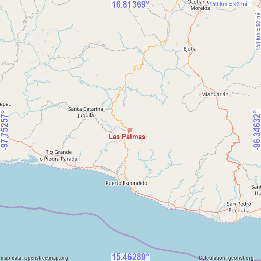
Las Palmas GPS coordinates[2]
16° 8' 21.984" North, 97° 2' 57.984" West
| Map corner | latitude | longitude |
|---|---|---|
| Upper-left | 16.81369°, | -97.75257° |
| Center: | 16.13944°, | -97.04944° |
| Lower-right: | 15.46289°, | -96.34632° |
| Map W x H: | 150.2×150.2 km | = 93.3×93.3mi |
| max Lat: | 32.7° ⇑96.7% North |
| Las Palmas: | 16.13944° |
| min Lat: | ⇓3.3% South 14.53588° |
| min Long | Las Palmas | max Long |
| -117.105° | -97.04944° | -86.73105° |
| W 74.2%⇐ | ⇒25.8% E |
Elevation
Elevation of Las Palmas is 840 m = 2756 ft, and this is 413.7 m = 1357 ft below average elevation for this country.
| Max E: |
3497 m = 11473 ft | 62.7% |
| Avg. | 1253.7 m = 4113 ft | |
| Las Palmas | 840 m = 2756 ft | |
Min E: |
-1 m = -3 ft | 37.3% |
See also: Mexico elevation on elevation.city.
Geographical zone
Las Palmas is located in North Torrid zone (between Equator and Tropic of Cancer). Distance of this Northern Tropic circle is 811.4 km =504.2 mi to North.| Distance of | km | miles | from Las Palmas |
|---|---|---|---|
| North Pole | 8212.5 | 5103 | to North |
| Arctic Circle | 5606.6 | 3483.8 | to North |
| Tropic Cancer | 811.4 | 504.2 | to North |
| Equator | 1794.5 | 1115.1 | to South |


Nearby cities:
15 places around Las Palmas: (largest is in red/bold)
• Cañada de Guadalupe
12 km =7.5 mi,  280°
280°
• Cerro del Aire
16.9 km =10.5 mi,  258°
258°
• El Huarumbo
16.9 km =10.5 mi,  193°
193°
• La Reforma
18.4 km =11.4 mi,  157°
157°
• San Andrés Copala
18.7 km =11.6 mi,  213°
213°
• San Gabriel Mixtepec
6 km =3.7 mi,  216°
216°
• San José Atotonilco
14.6 km =9.1 mi, 255°
• San Juan Lachao
8.3 km =5.2 mi,  285°
285°
• San Pedro Mixtepec
17.8 km =11.1 mi, 190°
• Santa Lucía Teotepec
17 km =10.6 mi,  271°
271°
• Santa María Temaxcaltepec
16 km =9.9 mi, 280°
• Santa María Tiltepec
15.5 km =9.6 mi,  236°
236°
• Santiago Cuixtla
16.9 km =10.5 mi, 239°
• Santos Reyes Nopala
10.8 km =6.7 mi,  250°
250°
• Soledad Piedra Larga
2.5 km =1.6 mi,  101°
101°
Sources, notices
• [Note1] Compared only with cities in Mexico existing in our database
• [Src1] Map data: © OpenStreetMap contributors (CC-BY-SA)
• [Src2] Other city data from geonames.org with taken over terms of usage.
• [Src3] Geographical zone / Annual Mean Temperature by Robert A. Rohde @ Wikipedia
