Patria Nueva geodata
Patria Nueva (Oaxaca) is a populated place; located in Mexico in America/Mexico_City (GMT-6) time zone. With population of 777 people, there are 11245 cities with bigger population in this country. Compared to other cities in Mexico, 96.5% of cities are located further ↑North; 66.1% of cities are located further ←West and 82.8% of cities have higher elevation than Patria Nueva. Note1


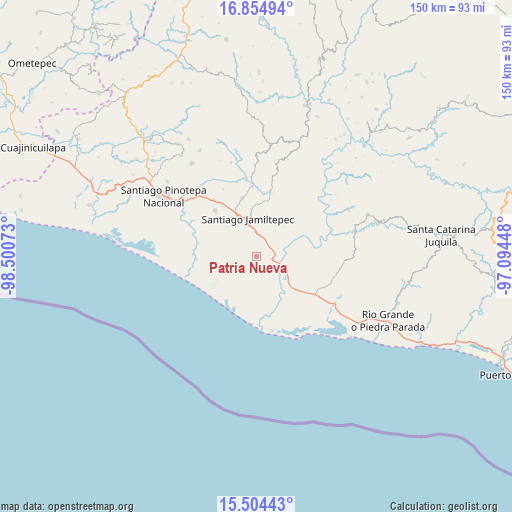
Patria Nueva GPS coordinates[2]
16° 10' 51.024" North, 97° 47' 51.36" West
| Map corner | latitude | longitude |
|---|---|---|
| Upper-left | 16.85494°, | -98.50073° |
| Center: | 16.18084°, | -97.7976° |
| Lower-right: | 15.50443°, | -97.09448° |
| Map W x H: | 150.2×150.2 km | = 93.3×93.3mi |
| max Lat: | 32.7° ⇑96.5% North |
| Patria Nueva: | 16.18084° |
| min Lat: | ⇓3.5% South 14.53588° |
| min Long | Patria Nueva | max Long |
| -117.105° | -97.7976° | -86.73105° |
| W 66.1%⇐ | ⇒33.9% E |
Elevation
Elevation of Patria Nueva is 62 m = 203 ft, and this is 1191.7 m = 3910 ft below average elevation for this country.
| Max E: |
3497 m = 11473 ft | 82.8% |
| Avg. | 1253.7 m = 4113 ft | |
| Patria Nueva | 62 m = 203 ft | |
Min E: |
-1 m = -3 ft | 17.2% |
See also: Mexico elevation on elevation.city.
Geographical zone
Patria Nueva is located in North Torrid zone (between Equator and Tropic of Cancer). Distance of this Northern Tropic circle is 806.8 km =501.3 mi to North.| Distance of | km | miles | from Patria Nueva |
|---|---|---|---|
| North Pole | 8207.9 | 5100.2 | to North |
| Arctic Circle | 5602 | 3480.9 | to North |
| Tropic Cancer | 806.8 | 501.3 | to North |
| Equator | 1799.1 | 1117.9 | to South |


Nearby cities:
15 places around Patria Nueva: (largest is in red/bold)
• Cerro de la Esperanza
19.7 km =12.2 mi,  280°
280°
• Charco Nduayoo
4.9 km =3 mi,  103°
103°
• Collantes
18.6 km =11.6 mi,  272°
272°
• Jamiltepec
11.7 km =7.3 mi,  345°
345°
• José María Morelos
14.4 km =8.9 mi, 280°
• Paso del Jiote
17.7 km =11 mi, 282°
• San Andrés Huaxpaltepec
20.8 km =12.9 mi,  322°
322°
• San José Río Verde (La Boquilla)
6.8 km =4.2 mi,  135°
135°
• San José del Progreso
14.5 km =9 mi,  130°
130°
• Santa Catarina Mechoacán
17.7 km =11 mi, 346°
• Santa Cruz Tihuixte
21 km =13 mi,  43°
43°
• Santa Elena Comaltepec
15.3 km =9.5 mi,  359°
359°
• Santa María Chico Ometepec
18.1 km =11.2 mi, 267°
• Santa María Huazolotitlán
18.4 km =11.4 mi, 317°
• Santiago Tetepec
16.5 km =10.3 mi,  18°
18°
Sources, notices
• [Note1] Compared only with cities in Mexico existing in our database
• [Src1] Map data: © OpenStreetMap contributors (CC-BY-SA)
• [Src2] Other city data from geonames.org with taken over terms of usage.
• [Src3] Geographical zone / Annual Mean Temperature by Robert A. Rohde @ Wikipedia
