Paso del Jiote geodata
Paso del Jiote (Oaxaca) is a populated place; located in Mexico in America/Mexico_City (GMT-6) time zone. With population of 716 people, there are 12166 cities with bigger population in this country. Compared to other cities in Mexico, 96.2% of cities are located further ↑North; 64.1% of cities are located further ←West and 90.8% of cities have higher elevation than Paso del Jiote. Note1


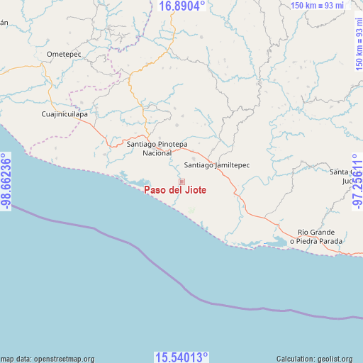
Paso del Jiote GPS coordinates[2]
16° 12' 59.112" North, 97° 57' 33.228" West
| Map corner | latitude | longitude |
|---|---|---|
| Upper-left | 16.8904°, | -98.66236° |
| Center: | 16.21642°, | -97.95923° |
| Lower-right: | 15.54013°, | -97.25611° |
| Map W x H: | 150.1×150.1 km | = 93.3×93.3mi |
| max Lat: | 32.7° ⇑96.2% North |
| Paso del Jiote: | 16.21642° |
| min Lat: | ⇓3.8% South 14.53588° |
| min Long | Paso del Jiote | max Long |
| -117.105° | -97.95923° | -86.73105° |
| W 64.1%⇐ | ⇒35.9% E |
Elevation
Elevation of Paso del Jiote is 22 m = 72 ft, and this is 1231.7 m = 4041 ft below average elevation for this country.
| Max E: |
3497 m = 11473 ft | 90.8% |
| Avg. | 1253.7 m = 4113 ft | |
| Paso del Jiote | 22 m = 72 ft | |
Min E: |
-1 m = -3 ft | 9.2% |
See also: Mexico elevation on elevation.city.
Geographical zone
Paso del Jiote is located in North Torrid zone (between Equator and Tropic of Cancer). Distance of this Northern Tropic circle is 802.8 km =498.8 mi to North.| Distance of | km | miles | from Paso del Jiote |
|---|---|---|---|
| North Pole | 8204 | 5097.7 | to North |
| Arctic Circle | 5598.1 | 3478.5 | to North |
| Tropic Cancer | 802.8 | 498.8 | to North |
| Equator | 1803.1 | 1120.4 | to South |


Nearby cities:
15 places around Paso del Jiote: (largest is in red/bold)
• Cerro de la Esperanza
2.1 km =1.3 mi,  259°
259°
• Collantes
3.4 km =2.1 mi,  203°
203°
• Cruz del Itacuán
10.5 km =6.5 mi,  318°
318°
• Cubitán de Dolores
17.5 km =10.9 mi,  24°
24°
• El Carrizo
8.7 km =5.4 mi,  299°
299°
• Jamiltepec
16.2 km =10.1 mi,  62°
62°
• José María Morelos
3.4 km =2.1 mi,  114°
114°
• Patria Nueva
17.7 km =11 mi,  102°
102°
• Piedra Blanca
6.3 km =3.9 mi, 320°
• Pinotepa Nacional
17 km =10.6 mi, 323°
• Rancho Viejo
13.7 km =8.5 mi,  357°
357°
• San Andrés Huaxpaltepec
13.4 km =8.3 mi, 19°
• Santa Catarina Mechoacán
18.6 km =11.6 mi,  44°
44°
• Santa María Chico Ometepec
4.7 km =2.9 mi,  189°
189°
• Santa María Huazolotitlán
10.9 km =6.8 mi,  27°
27°
Sources, notices
• [Note1] Compared only with cities in Mexico existing in our database
• [Src1] Map data: © OpenStreetMap contributors (CC-BY-SA)
• [Src2] Other city data from geonames.org with taken over terms of usage.
• [Src3] Geographical zone / Annual Mean Temperature by Robert A. Rohde @ Wikipedia
