Almolonga geodata
Almolonga (Oaxaca) is a populated place; located in Mexico in America/Mexico_City (GMT-6) time zone. With population of 1,325 people, there are 6547 cities with bigger population in this country. Compared to other cities in Mexico, 71.3% of cities are located further ↑North; 78.8% of cities are located further ←West and 75.7% of cities have higher elevation than Almolonga. Note1


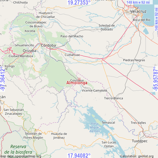
Almolonga GPS coordinates[2]
18° 36' 30.528" North, 96° 39' 39.564" West
| Map corner | latitude | longitude |
|---|---|---|
| Upper-left | 19.27353°, | -97.36412° |
| Center: | 18.60848°, | -96.66099° |
| Lower-right: | 17.94082°, | -95.95787° |
| Map W x H: | 148.2×148.2 km | = 92.1×92.1mi |
| max Lat: | 32.7° ⇑71.3% North |
| Almolonga: | 18.60848° |
| min Lat: | ⇓28.7% South 14.53588° |
| min Long | Almolonga | max Long |
| -117.105° | -96.66099° | -86.73105° |
| W 78.8%⇐ | ⇒21.2% E |
Elevation
Elevation of Almolonga is 198 m = 650 ft, and this is 1055.7 m = 3464 ft below average elevation for this country.
| Max E: |
3497 m = 11473 ft | 75.7% |
| Avg. | 1253.7 m = 4113 ft | |
| Almolonga | 198 m = 650 ft | |
Min E: |
-1 m = -3 ft | 24.3% |
See also: Mexico elevation on elevation.city.
Geographical zone
Almolonga is located in North Torrid zone (between Equator and Tropic of Cancer). Distance of this Northern Tropic circle is 536.8 km =333.6 mi to North.| Distance of | km | miles | from Almolonga |
|---|---|---|---|
| North Pole | 7938 | 4932.4 | to North |
| Arctic Circle | 5332.1 | 3313.2 | to North |
| Tropic Cancer | 536.8 | 333.6 | to North |
| Equator | 2069.1 | 1285.7 | to South |


Nearby cities:
15 places around Almolonga: (largest is in red/bold)
• Acatlán de Pérez Figueroa
9.6 km =6 mi,  142°
142°
• Barbasco
11 km =6.8 mi,  104°
104°
• Colonia Primero de Mayo
8 km =5 mi,  37°
37°
• Cosolapa
2.7 km =1.7 mi,  250°
250°
• Cruz Tetela
11.5 km =7.1 mi,  322°
322°
• Laguna Chica (Pueblo Nuevo)
10.5 km =6.5 mi,  226°
226°
• Loma del Izote (Mata Planta)
6.3 km =3.9 mi,  74°
74°
• Motzorongo
8.1 km =5 mi,  297°
297°
• Palma Sola
4 km =2.5 mi, 71°
• Paso Amapa
4.7 km =2.9 mi,  12°
12°
• Paso Nuevo
8.9 km =5.5 mi,  92°
92°
• Río Moreno
7.8 km =4.8 mi, 10°
• San Agustín del Palmar
12 km =7.5 mi,  211°
211°
• Tezonapa
2.4 km =1.5 mi,  266°
266°
• Zona Urbana Ejidal
11.3 km =7 mi, 138°
Sources, notices
• [Note1] Compared only with cities in Mexico existing in our database
• [Src1] Map data: © OpenStreetMap contributors (CC-BY-SA)
• [Src2] Other city data from geonames.org with taken over terms of usage.
• [Src3] Geographical zone / Annual Mean Temperature by Robert A. Rohde @ Wikipedia
