Paso Amapa geodata
Paso Amapa (Veracruz) is a populated place; located in Mexico in America/Mexico_City (GMT-6) time zone. With population of 740 people, there are 11812 cities with bigger population in this country. Compared to other cities in Mexico, 70.8% of cities are located further ↑North; 78.8% of cities are located further ←West and 75.2% of cities have higher elevation than Paso Amapa. Note1


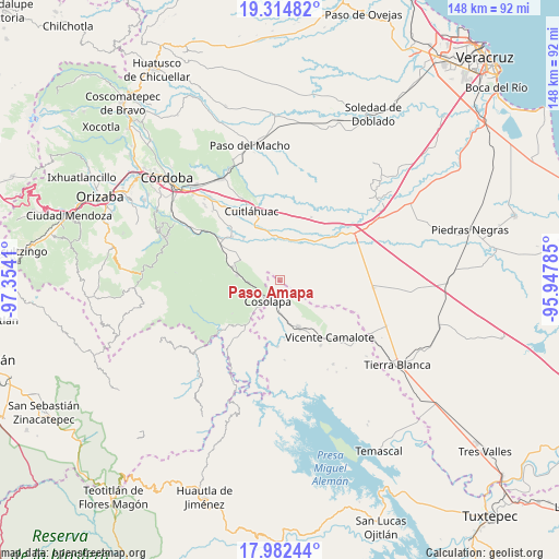
Paso Amapa GPS coordinates[2]
18° 38' 59.784" North, 96° 39' 3.492" West
| Map corner | latitude | longitude |
|---|---|---|
| Upper-left | 19.31482°, | -97.3541° |
| Center: | 18.64994°, | -96.65097° |
| Lower-right: | 17.98244°, | -95.94785° |
| Map W x H: | 148.1×148.1 km | = 92×92mi |
| max Lat: | 32.7° ⇑70.8% North |
| Paso Amapa: | 18.64994° |
| min Lat: | ⇓29.2% South 14.53588° |
| min Long | Paso Amapa | max Long |
| -117.105° | -96.65097° | -86.73105° |
| W 78.8%⇐ | ⇒21.2% E |
Elevation
Elevation of Paso Amapa is 214 m = 702 ft, and this is 1039.7 m = 3411 ft below average elevation for this country.
| Max E: |
3497 m = 11473 ft | 75.2% |
| Avg. | 1253.7 m = 4113 ft | |
| Paso Amapa | 214 m = 702 ft | |
Min E: |
-1 m = -3 ft | 24.8% |
See also: Mexico elevation on elevation.city.
Geographical zone
Paso Amapa is located in North Torrid zone (between Equator and Tropic of Cancer). Distance of this Northern Tropic circle is 532.2 km =330.7 mi to North.| Distance of | km | miles | from Paso Amapa |
|---|---|---|---|
| North Pole | 7933.4 | 4929.6 | to North |
| Arctic Circle | 5327.5 | 3310.4 | to North |
| Tropic Cancer | 532.2 | 330.7 | to North |
| Equator | 2073.7 | 1288.5 | to South |


Nearby cities:
15 places around Paso Amapa: (largest is in red/bold)
• Almolonga
4.7 km =2.9 mi,  192°
192°
• Bajo Grande
10.3 km =6.4 mi,  16°
16°
• Colonia Primero de Mayo
4.2 km =2.6 mi,  66°
66°
• Cosolapa
6.6 km =4.1 mi,  213°
213°
• Cruz Tetela
9.3 km =5.8 mi,  298°
298°
• Emiliano Zapata
11.5 km =7.1 mi,  305°
305°
• Loma Mulato
8.9 km =5.5 mi,  30°
30°
• Loma del Izote (Mata Planta)
5.7 km =3.5 mi,  120°
120°
• Mata Tenatito (Casco Hacienda)
8.1 km =5 mi,  351°
351°
• Motzorongo
8.3 km =5.2 mi,  264°
264°
• Palma Sola
4.3 km =2.7 mi,  141°
141°
• Paso Nuevo
9.3 km =5.8 mi, 122°
• Paso del Rosario
11.4 km =7.1 mi,  325°
325°
• Río Moreno
3.1 km =1.9 mi,  7°
7°
• Tezonapa
5.9 km =3.7 mi,  216°
216°
Sources, notices
• [Note1] Compared only with cities in Mexico existing in our database
• [Src1] Map data: © OpenStreetMap contributors (CC-BY-SA)
• [Src2] Other city data from geonames.org with taken over terms of usage.
• [Src3] Geographical zone / Annual Mean Temperature by Robert A. Rohde @ Wikipedia
