Loma de Piedra geodata
Loma de Piedra (Oaxaca) is a populated place; located in Mexico in America/Mexico_City (GMT-6) time zone. With population of 667 people, there are 13011 cities with bigger population in this country. Compared to other cities in Mexico, 77.6% of cities are located further ↑North; 80% of cities are located further ←West and 79.1% of cities have higher elevation than Loma de Piedra. Note1


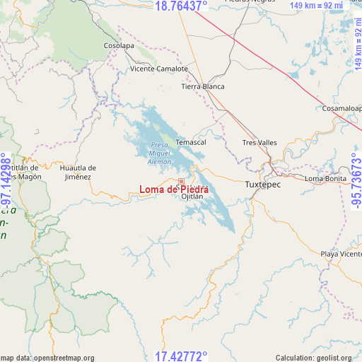
Loma de Piedra GPS coordinates[2]
18° 5' 50.352" North, 96° 26' 23.46" West
| Map corner | latitude | longitude |
|---|---|---|
| Upper-left | 18.76437°, | -97.14298° |
| Center: | 18.09732°, | -96.43985° |
| Lower-right: | 17.42772°, | -95.73673° |
| Map W x H: | 148.6×148.6 km | = 92.3×92.3mi |
| max Lat: | 32.7° ⇑77.6% North |
| Loma de Piedra: | 18.09732° |
| min Lat: | ⇓22.4% South 14.53588° |
| min Long | Loma de Piedra | max Long |
| -117.105° | -96.43985° | -86.73105° |
| W 80%⇐ | ⇒20% E |
Elevation
Elevation of Loma de Piedra is 109 m = 358 ft, and this is 1144.7 m = 3756 ft below average elevation for this country.
| Max E: |
3497 m = 11473 ft | 79.1% |
| Avg. | 1253.7 m = 4113 ft | |
| Loma de Piedra | 109 m = 358 ft | |
Min E: |
-1 m = -3 ft | 20.9% |
See also: Mexico elevation on elevation.city.
Geographical zone
Loma de Piedra is located in North Torrid zone (between Equator and Tropic of Cancer). Distance of this Northern Tropic circle is 593.7 km =368.9 mi to North.| Distance of | km | miles | from Loma de Piedra |
|---|---|---|---|
| North Pole | 7994.8 | 4967.7 | to North |
| Arctic Circle | 5388.9 | 3348.5 | to North |
| Tropic Cancer | 593.7 | 368.9 | to North |
| Equator | 2012.2 | 1250.3 | to South |


Nearby cities:
15 places around Loma de Piedra: (largest is in red/bold)
• Agua de Tierra (Sección la Montaña)
7.1 km =4.4 mi,  261°
261°
• Arroyo Camalote
3.6 km =2.2 mi,  104°
104°
• Arroyo Grande
6.2 km =3.9 mi,  271°
271°
• Arroyo Tigre
3.8 km =2.4 mi,  355°
355°
• Benito Juárez II (San Martín)
5.3 km =3.3 mi,  334°
334°
• La Permuta
5.2 km =3.2 mi, 267°
• Laguna Arroyo Grande
2.3 km =1.4 mi,  124°
124°
• Los Zarates
7.8 km =4.8 mi,  277°
277°
• Nuevo Pescadito de Abajo Dos
6.8 km =4.2 mi,  36°
36°
• Piedra de Amolar
2.8 km =1.7 mi, 334°
• Playa de Soyaltepec
2.8 km =1.7 mi,  60°
60°
• San José Lagunas
6.2 km =3.9 mi,  72°
72°
• San Lucas Ojitlán
6.2 km =3.9 mi,  135°
135°
• Sección los Roques
6.9 km =4.3 mi, 276°
• Vista Hermosa
7.8 km =4.8 mi,  188°
188°
Sources, notices
• [Note1] Compared only with cities in Mexico existing in our database
• [Src1] Map data: © OpenStreetMap contributors (CC-BY-SA)
• [Src2] Other city data from geonames.org with taken over terms of usage.
• [Src3] Geographical zone / Annual Mean Temperature by Robert A. Rohde @ Wikipedia
