San José Lagunas geodata
San José Lagunas (Oaxaca) is a populated place; located in Mexico in America/Mexico_City (GMT-6) time zone. With population of 570 people, there are 15008 cities with bigger population in this country. Compared to other cities in Mexico, 77.4% of cities are located further ↑North; 80.4% of cities are located further ←West and 79.5% of cities have higher elevation than San José Lagunas. Note1


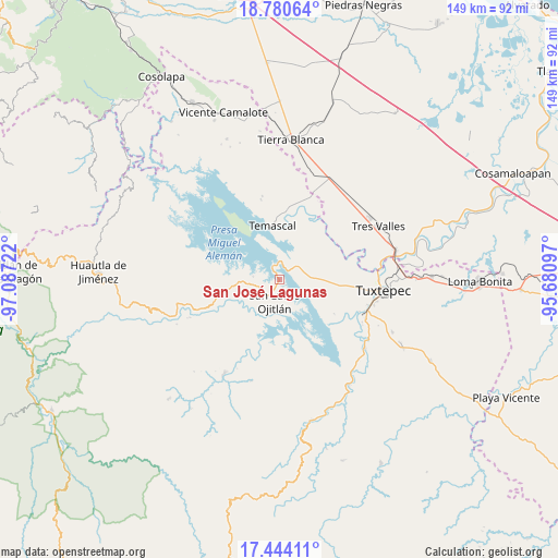
San José Lagunas GPS coordinates[2]
18° 6' 49.14" North, 96° 23' 2.724" West
| Map corner | latitude | longitude |
|---|---|---|
| Upper-left | 18.78064°, | -97.08722° |
| Center: | 18.11365°, | -96.38409° |
| Lower-right: | 17.44411°, | -95.68097° |
| Map W x H: | 148.6×148.6 km | = 92.3×92.3mi |
| max Lat: | 32.7° ⇑77.4% North |
| San José Lagunas: | 18.11365° |
| min Lat: | ⇓22.6% South 14.53588° |
| min Long | San José Lagun | max Long |
| -117.105° | -96.38409° | -86.73105° |
| W 80.4%⇐ | ⇒19.6% E |
Elevation
Elevation of San José Lagunas is 103 m = 338 ft, and this is 1150.7 m = 3775 ft below average elevation for this country.
| Max E: |
3497 m = 11473 ft | 79.5% |
| Avg. | 1253.7 m = 4113 ft | |
| San José Lagunas | 103 m = 338 ft | |
Min E: |
-1 m = -3 ft | 20.5% |
See also: Mexico elevation on elevation.city.
Geographical zone
San José Lagunas is located in North Torrid zone (between Equator and Tropic of Cancer). Distance of this Northern Tropic circle is 591.9 km =367.8 mi to North.| Distance of | km | miles | from San José Lagunas |
|---|---|---|---|
| North Pole | 7993 | 4966.6 | to North |
| Arctic Circle | 5387.1 | 3347.4 | to North |
| Tropic Cancer | 591.9 | 367.8 | to North |
| Equator | 2014 | 1251.4 | to South |


Nearby cities:
15 places around San José Lagunas: (largest is in red/bold)
• Arroyo Camalote
3.6 km =2.2 mi,  221°
221°
• Arroyo Grande
12.2 km =7.6 mi,  262°
262°
• Arroyo Tigre
6.5 km =4 mi,  287°
287°
• Benito Juárez II (San Martín)
8.7 km =5.4 mi, 290°
• Buenos Aires el Apompo
10.5 km =6.5 mi,  71°
71°
• Cerro Tepezcuintle
5.8 km =3.6 mi,  50°
50°
• La Permuta
11.3 km =7 mi, 259°
• Laguna Arroyo Grande
5.1 km =3.2 mi,  231°
231°
• Loma de Piedra
6.2 km =3.9 mi,  252°
252°
• Mazín Grande
7.9 km =4.9 mi,  87°
87°
• Nuevo Pescadito de Abajo Dos
4.1 km =2.5 mi,  333°
333°
• Piedra de Amolar
7.1 km =4.4 mi,  275°
275°
• Playa de Soyaltepec
3.5 km =2.2 mi, 262°
• San Lucas Ojitlán
6.4 km =4 mi,  193°
193°
• Vista Hermosa
11.8 km =7.3 mi, 216°
Sources, notices
• [Note1] Compared only with cities in Mexico existing in our database
• [Src1] Map data: © OpenStreetMap contributors (CC-BY-SA)
• [Src2] Other city data from geonames.org with taken over terms of usage.
• [Src3] Geographical zone / Annual Mean Temperature by Robert A. Rohde @ Wikipedia
